Old Maps of Loring, Alaska for Genealogy
Trace your family roots with 6 historic maps of Loring. These high-res maps reveal old neighborhoods, homesites, landmarks, and streets — helping you uncover where your ancestors lived and how the area evolved over time.
- Explore historic neighborhoods: Identify where your relatives may have lived in the 1800s or 1900s.
- Compare maps over time: Trace the changes in streets, buildings, and landmarks for multi-generational research.
- Perfect for genealogy & ancestry research: Used by family historians and researchers to map out lineage and migration.
These maps are an incredible resource for exploring your personal connection to Loring's past.
Loring, AK maps
(6)- 1948 Map of Ketchikan C-5, 1964 Print
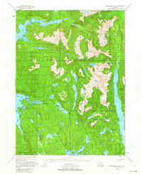 1948 Ketchikan C-51964 Print · USGSRevillagigedo Island in the late 1940s was a landscape of remote coastal outposts and vital salmon-bearing waterways. Researchers can locate the settlement of Loring, the Black Bear Observation Post, and the Fish Hatchery along the Naha River corridor.3 unique versions available
 - 1952 Map of Ketchikan, 1953 Print
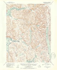
 1952 Ketchikan1953 Print · USGSThe Ketchikan region of Southeast Alaska is mapped here in the early fifties, documenting the remote settlements and deep-water inlets of the southern panhandle. Genealogists and historians can trace the foundations of Ketchikan, Metlakatla, and Saxman alongside lonely backcountry cabins.4 unique versions available
 - 1953 Map of Ketchikan C-5, 1954 Print
 1953 Ketchikan C-51954 Print · USGSRevillagigedo Island in the early 1950s was a landscape of remote outposts and coastal inlets. Researchers can locate the settlement of Loring, the Fish Hatchery (Aban'd) at Heckman Lake, and the Black Bear Observation Post near Roosevelt Lagoon.2 unique versions available
 - 1955 Map of Ketchikan, 1966 Print
 1955 Ketchikan1966 Print · USGSSoutheast Alaska’s maritime character is captured in the mid-fifties, showing the vital waterways and remote outposts of the Alexander Archipelago. Researchers can trace the waterfronts of Ketchikan and Metlakatla or locate isolated spots like Hyder and Loring.3 unique versions available
 - 2017 Map of Ketchikan C-5 SW, 2017 Print
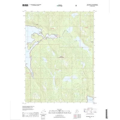 2017 Ketchikan C-5 SW2017 Print · USGSCovers Loring, including Ketchikan Gateway, United States, and other nearby areas
 - 2021 Map of Ketchikan C-5 SW, 2021 Print
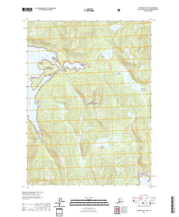 2021 Ketchikan C-5 SW2021 Print · USGSThe coastal settlement of Loring and the Tongass National Forest are depicted in this 2021 survey of the Ketchikan region. Researchers can trace the water systems of Jordan Lake and Leask Lake or locate landmarks like Dogfish Island.
End of results
Showing maps 1-6 of 6
Frequently asked questions
- What are the different types of historical maps available for Loring?
- What is the oldest map of Loring?
- Where can I purchase historical maps of Loring for my home or office?
- Where can I download high-res historical maps of Loring?
- Are there historical topographic maps available for Loring?
- Is there historical aerial imagery available for Loring?
- Where are historical maps of Loring sourced from?