Old Maps of Aleksashkina, Alaska for Metal Detecting
Plan your next treasure hunt with 5 historic maps of Aleksashkina. Find old homesites, ghost towns, trails, and gathering spots that may be lost to time — perfect for identifying promising metal detecting locations.
- Locate forgotten sites: Uncover places like long-lost settlements, abandoned rail lines, or gathering spots.
- Plan better hunts: Use map overlays combined with LiDAR or satellite views to narrow in on historically rich areas.
- Made for detectorists: Thousands of hobbyists use these maps to discover relics, coins, and hidden history.
Use these historic maps to boost your research and find new opportunities beneath the surface of Aleksashkina.
Aleksashkina, AK maps
(5)- 1949 Map of Kodiak D-2, 1958 Print
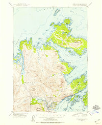 1949 Kodiak D-21958 Print · USGSKodiak Island and Spruce Island are shown just after the war as the region's naval presence and coastal settlements like Kodiak and Uzinki expanded. Researchers can trace military landmarks within the U S Naval Reservation or locate family-named features like Balika Basin and Melnitsa Lake.5 unique versions available
 - 1951 Map of Kodiak D-2
 1951 Kodiak D-21951 Print · USGSKodiak Island during the early Cold War years shows a landscape heavily influenced by strategic defense and maritime trade. Researchers can trace the bounds of the Fort Greeley Military Reservation, locate the village of Uzinki, and follow the winding Pillar Mountain Road.2 unique versions available
 - 1952 Map of Kodiak, 1953 Print
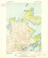
 1952 Kodiak1953 Print · USGSKodiak Island in the early fifties shows a landscape of strategic military bases and coastal fishing villages. Researchers can trace the layout of the Naval Reservation, the whaling station at Port Hobron, and remote settlements like Old Harbor.12 unique versions available
 - 1987 Map of Kodiak D-2 SE, 1988 Print
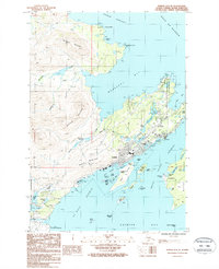 1987 Kodiak D-2 SE1988 Print · USGSKodiak Island comes to life in the late eighties, showing the bustling waterfront of Kodiak and the surrounding coastal outposts. Researchers can trace the development of Fort Abercrombie or locate the settlement of Aleksashkina on Woody Island.2 unique versions available
 - 2021 Map of Kodiak D-2 SE, 2021 Print
 2021 Kodiak D-2 SE2021 Print · USGSKodiak Island at the start of the 2020s shows a busy maritime and educational hub surrounding the city of Kodiak. Local historians can trace the development of Mill Bay and the coastline near Kodiak College and Woody Island.
End of results
Showing maps 1-5 of 5
Top cities near Aleksashkina
Frequently asked questions
- What are the different types of historical maps available for Aleksashkina?
- What is the oldest map of Aleksashkina?
- Where can I purchase historical maps of Aleksashkina for my home or office?
- Where can I download high-res historical maps of Aleksashkina?
- Are there historical topographic maps available for Aleksashkina?
- Is there historical aerial imagery available for Aleksashkina?
- Where are historical maps of Aleksashkina sourced from?