Old Maps of Aleneva, Alaska for Metal Detecting
Plan your next treasure hunt with 4 historic maps of Aleneva. Find old homesites, ghost towns, trails, and gathering spots that may be lost to time — perfect for identifying promising metal detecting locations.
- Locate forgotten sites: Uncover places like long-lost settlements, abandoned rail lines, or gathering spots.
- Plan better hunts: Use map overlays combined with LiDAR or satellite views to narrow in on historically rich areas.
- Made for detectorists: Thousands of hobbyists use these maps to discover relics, coins, and hidden history.
Use these historic maps to boost your research and find new opportunities beneath the surface of Aleneva.
Aleneva, AK maps
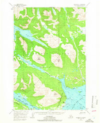
(4)- 1952 Map of Afognak, 1953 Print
 1952 Afognak1953 Print · USGSThe Afognak and Shelikof Strait region in the early fifties shows a remote landscape of maritime outposts and glacier-fed coasts. Researchers can locate coastal settlements like Port William, the Hatchery on Afognak, and the isolated village of Kaguyak.10 unique versions available
 - 1952 Map of Afognak A-3, 1966 Print
 1952 Afognak A-31966 Print · USGSAfognak Island in the early 1950s shows a landscape defined by maritime heritage and the deep forests of the Chugach. Genealogists and researchers can trace the coastal layout of Afognak and Aleut Village or locate the old Recreation Camp on Afognak Lake.4 unique versions available
 - 1954 Map of Afognak A-3, 1955 Print
 1954 Afognak A-31955 Print · USGSAfognak Island in the mid-fifties reveals a landscape of isolated coastal settlements and deep glacial bays. Genealogists and local historians can locate the Aleut Village, the old townsite of Afognak, and infrastructure like the Covered Bridge on the Afognak River.
 - 2021 Map of Afognak A-3 SW, 2021 Print
 2021 Afognak A-3 SW2021 Print · USGSCoastal life in the Kodiak Archipelago remains centered on the remote settlement of Aleneva and its surrounding wilderness. Researchers can trace the maritime geography of Raspberry Strait, the elevation of Afognak Mtn, and the freshwater systems of Afognak Lake.
End of results
Showing maps 1-4 of 4
Top cities near Aleneva
Frequently asked questions
- What are the different types of historical maps available for Aleneva?
- What is the oldest map of Aleneva?
- Where can I purchase historical maps of Aleneva for my home or office?
- Where can I download high-res historical maps of Aleneva?
- Are there historical topographic maps available for Aleneva?
- Is there historical aerial imagery available for Aleneva?
- Where are historical maps of Aleneva sourced from?