Old Maps of Aleut Village, Alaska for Genealogy
Trace your family roots with 4 historic maps of Aleut Village. These high-res maps reveal old neighborhoods, homesites, landmarks, and streets — helping you uncover where your ancestors lived and how the area evolved over time.
- Explore historic neighborhoods: Identify where your relatives may have lived in the 1800s or 1900s.
- Compare maps over time: Trace the changes in streets, buildings, and landmarks for multi-generational research.
- Perfect for genealogy & ancestry research: Used by family historians and researchers to map out lineage and migration.
These maps are an incredible resource for exploring your personal connection to Aleut Village's past.
Aleut Village, AK maps
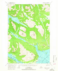
(4)- 1952 Map of Afognak, 1953 Print
 1952 Afognak1953 Print · USGSThe Afognak and Shelikof Strait region in the early fifties shows a remote landscape of maritime outposts and glacier-fed coasts. Researchers can locate coastal settlements like Port William, the Hatchery on Afognak, and the isolated village of Kaguyak.10 unique versions available
 - 1952 Map of Afognak A-3, 1966 Print
 1952 Afognak A-31966 Print · USGSAfognak Island in the early 1950s shows a landscape defined by maritime heritage and the deep forests of the Chugach. Genealogists and researchers can trace the coastal layout of Afognak and Aleut Village or locate the old Recreation Camp on Afognak Lake.4 unique versions available
 - 1954 Map of Afognak A-3, 1955 Print
 1954 Afognak A-31955 Print · USGSAfognak Island in the mid-fifties reveals a landscape of isolated coastal settlements and deep glacial bays. Genealogists and local historians can locate the Aleut Village, the old townsite of Afognak, and infrastructure like the Covered Bridge on the Afognak River.
 - 2021 Map of Afognak A-3 SE, 2021 Print
 2021 Afognak A-3 SE2021 Print · USGSAfognak Bay and the surrounding Kodiak Island coastline are documented here in the early twenty-first century. Researchers can trace landforms and coastal settlements like Afognak, while locating maritime markers such as Graveyard Point and Village Reefs.
End of results
Showing maps 1-4 of 4
Top cities near Aleut Village
Frequently asked questions
- What are the different types of historical maps available for Aleut Village?
- What is the oldest map of Aleut Village?
- Where can I purchase historical maps of Aleut Village for my home or office?
- Where can I download high-res historical maps of Aleut Village?
- Are there historical topographic maps available for Aleut Village?
- Is there historical aerial imagery available for Aleut Village?
- Where are historical maps of Aleut Village sourced from?