Old Maps of Ayakulik, Alaska for Genealogy
Trace your family roots with 6 historic maps of Ayakulik. These high-res maps reveal old neighborhoods, homesites, landmarks, and streets — helping you uncover where your ancestors lived and how the area evolved over time.
- Explore historic neighborhoods: Identify where your relatives may have lived in the 1800s or 1900s.
- Compare maps over time: Trace the changes in streets, buildings, and landmarks for multi-generational research.
- Perfect for genealogy & ancestry research: Used by family historians and researchers to map out lineage and migration.
These maps are an incredible resource for exploring your personal connection to Ayakulik's past.
Ayakulik, AK maps
(6)- 1951 Map of Karluk, 1952 Print
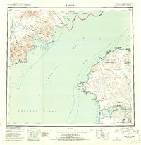 1951 Karluk1952 Print · USGSThe Kodiak archipelago and the rugged Katmai coast are shown in the early fifties before statehood. Genealogists and historians can trace the early industrial footprint of the Cannery at Larsen Bay and the isolated settlement at Karluk.
 - 1952 Map of Karluk, 1957 Print
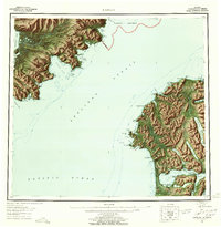 1952 Karluk1957 Print · USGSShelikof Strait and the shores of Kodiak Island appear here in the early fifties, documenting a landscape of remote settlements and maritime industry. Trace the locations of a Cannery, an Oil Well near Kanatak, and the Seaplane Airport that connected these coastal outposts.7 unique versions available
 - 1952 Map of Karluk A-2, 1975 Print
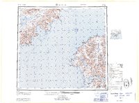
 1952 Karluk A-21975 Print · USGSKodiak Island in the early fifties shows a remote coastal landscape shaped by the Ayakulik River and the Pacific. Trace isolated wilderness outposts like Ayakulik and the Fish and Wildlife Service Upper Station near Olga Bay.3 unique versions available
 - 1954 Map of Karluk A-2, 1955 Print
 1954 Karluk A-21955 Print · USGSKodiak Island's rugged southwestern coast and interior waterways are captured here during the mid-1950s. Researchers can locate remote outposts like Ayakulik and the Fish and Wildlife Service Upper Station along the shores of Olga Bay.
 - 1964 Map of Karluk
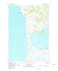
 1964 Karluk1964 Print · USGSKodiak Island and the Alaska Peninsula meet across the Shelikof Strait in the early sixties, a time when commercial fishing and wildlife management defined the region. Researchers can locate remote outposts like the Fish and Wildlife Service Upper Station and the Cannery at Larsen Bay.
 - 2021 Map of Karluk A-2 NW, 2021 Print
 2021 Karluk A-2 NW2021 Print · USGSCoastal Kodiak Island is documented in this recent survey, capturing the meeting of the wild tundra and the sea. Researchers can trace the winding course of the Ayakulik River toward Ayakulik Island and the heights of Oval Mtn.
End of results
Showing maps 1-6 of 6
Frequently asked questions
- What are the different types of historical maps available for Ayakulik?
- What is the oldest map of Ayakulik?
- Where can I purchase historical maps of Ayakulik for my home or office?
- Where can I download high-res historical maps of Ayakulik?
- Are there historical topographic maps available for Ayakulik?
- Is there historical aerial imagery available for Ayakulik?
- Where are historical maps of Ayakulik sourced from?