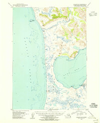
1954 Map of Karluk A-2
USGS Topo · Published 1955About this map
Kodiak Island's southwestern coast is defined by the winding course of the Ayakulik River and the protected waters of Olga Bay in this mid-century topographical record. This remote landscape within the Kodiak National Wildlife Refuge shows a sparse network of human activity, concentrated primarily around the coast and inland waterways. Small outposts such as Ayakulik and the Fish and Wildlife Service Upper Station on Olga Cr anchor the area, while numerous isolated labels like Cabin, Cabins, and Mud suggest seasonal use by hunters, researchers, or trappers. The terrain varies from the coastal elevations of Oval Mtn and Mt Myrtle to the low-lying stretches of Tundra and Sandy, illustrating the transition from the Pacific Ocean surf to the interior's complex hydrology.
Find a feature on this map
24 named features on this map. Tap any name to fly to it.
Don’t see what you’re looking for? This feature index may not catch every label — zoom into the map to look around manually.
Map Details
Editions of this 1954 Karluk A-2 Map
This is the sole edition of this map. No revisions or reprints were ever made.
Other maps of this area

1951 · Trinity Islands
USGS Topo · 1:250,000

1951 · Karluk
USGS Topo · 1:250,000

1952 · Karluk
USGS Topo · 1:250,000

1952 · Trinity Islands D-2
USGS Topo · 1:63,360

1952 · Karluk B-2
USGS Topo · 1:63,360

1952 · Karluk B-1
USGS Topo · 1:63,360

1952 · Trinity Islands D-1
USGS Topo · 1:63,360

1952 · Karluk A-1
USGS Topo · 1:63,360
1952 · Karluk B-3
USGS Topo · 1:63,360

1952 · Karluk A-2
USGS Topo · 1:63,360