Old Maps of Chiniak, Alaska for Genealogy
Trace your family roots with 5 historic maps of Chiniak. These high-res maps reveal old neighborhoods, homesites, landmarks, and streets — helping you uncover where your ancestors lived and how the area evolved over time.
- Explore historic neighborhoods: Identify where your relatives may have lived in the 1800s or 1900s.
- Compare maps over time: Trace the changes in streets, buildings, and landmarks for multi-generational research.
- Perfect for genealogy & ancestry research: Used by family historians and researchers to map out lineage and migration.
These maps are an incredible resource for exploring your personal connection to Chiniak's past.
Chiniak, AK maps
(5)- 1949 Map of Kodiak C-1, 1964 Print
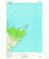 1949 Kodiak C-11964 Print · USGSKodiak Island at the end of the 1940s reveals a maritime-centered landscape of rugged points and vital early aviation sites. Researchers can trace the coastline from Cape Chiniak to the Sacramento River or locate the historic Miller Airstrip.3 unique versions available
 - 1951 Map of Kodiak C-1
 1951 Kodiak C-11951 Print · USGSKodiak Island's northeastern coast and its mid-century maritime features appear here just after the war years. Researchers can trace landforms from Cape Chiniak to Boyer Peak and locate the remote Airstrip and Sacramento River.2 unique versions available
 - 1952 Map of Kodiak, 1953 Print
 1952 Kodiak1953 Print · USGSKodiak Island in the early fifties shows a landscape of strategic military bases and coastal fishing villages. Researchers can trace the layout of the Naval Reservation, the whaling station at Port Hobron, and remote settlements like Old Harbor.12 unique versions available
 - 1987 Map of Kodiak C-1 NW, 1988 Print
 1987 Kodiak C-1 NW1988 Print · USGSKodiak Island’s rugged coastline and maritime hazards are documented in the late eighties as they appeared before modern environmental shifts. Map collectors and researchers can trace the detailed shoreline of Long Island and identify navigation points like Humpback Rock and Isthmus Point.
 - 2021 Map of Kodiak C-1 NW, 2021 Print
 2021 Kodiak C-1 NW2021 Print · USGSCoastal Kodiak Island is mapped here in recent years, showing the maritime geography of the gulf before the landscape changes further. Maritime researchers can locate specific hazards and landforms like Kalsin Reef, Kekur Island, and the coastal Chiniak Highway.
End of results
Showing maps 1-5 of 5
Top cities near Chiniak
Frequently asked questions
- What are the different types of historical maps available for Chiniak?
- What is the oldest map of Chiniak?
- Where can I purchase historical maps of Chiniak for my home or office?
- Where can I download high-res historical maps of Chiniak?
- Are there historical topographic maps available for Chiniak?
- Is there historical aerial imagery available for Chiniak?
- Where are historical maps of Chiniak sourced from?