Old Maps of Ouzinkie, Alaska for Genealogy
Trace your family roots with 5 historic maps of Ouzinkie. These high-res maps reveal old neighborhoods, homesites, landmarks, and streets — helping you uncover where your ancestors lived and how the area evolved over time.
- Explore historic neighborhoods: Identify where your relatives may have lived in the 1800s or 1900s.
- Compare maps over time: Trace the changes in streets, buildings, and landmarks for multi-generational research.
- Perfect for genealogy & ancestry research: Used by family historians and researchers to map out lineage and migration.
These maps are an incredible resource for exploring your personal connection to Ouzinkie's past.
Ouzinkie, AK maps
(5)- 1949 Map of Kodiak D-2, 1958 Print
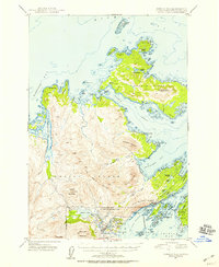 1949 Kodiak D-21958 Print · USGSKodiak Island and Spruce Island are shown just after the war as the region's naval presence and coastal settlements like Kodiak and Uzinki expanded. Researchers can trace military landmarks within the U S Naval Reservation or locate family-named features like Balika Basin and Melnitsa Lake.5 unique versions available
 - 1951 Map of Kodiak D-2
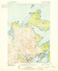 1951 Kodiak D-21951 Print · USGSKodiak Island during the early Cold War years shows a landscape heavily influenced by strategic defense and maritime trade. Researchers can trace the bounds of the Fort Greeley Military Reservation, locate the village of Uzinki, and follow the winding Pillar Mountain Road.2 unique versions available
 - 1952 Map of Kodiak, 1953 Print
 1952 Kodiak1953 Print · USGSKodiak Island in the early fifties shows a landscape of strategic military bases and coastal fishing villages. Researchers can trace the layout of the Naval Reservation, the whaling station at Port Hobron, and remote settlements like Old Harbor.12 unique versions available
 - 2021 Map of Kodiak D-2 NW, 2021 Print
 2021 Kodiak D-2 NW2021 Print · USGSKodiak Island's rugged northern coastline is documented here in the early twenty-first century as it centers on the waterways near Ouzinkie. Local history researchers can trace the coastal layout of Kizhuyak Bay and name landmarks like Three Brothers or Larsen Island.
 - 2021 Map of Kodiak D-2 NE, 2021 Print
 2021 Kodiak D-2 NE2021 Print · USGSSpruce Island and the coastal community of Ouzinkie are documented here during the early twenty-first century. Researchers can trace the local infrastructure from Ouzinkie Airport to the village streets, or explore the maritime geography of Narrow Strait and Marmot Bay.
End of results
Showing maps 1-5 of 5
Top cities near Ouzinkie
Frequently asked questions
- What are the different types of historical maps available for Ouzinkie?
- What is the oldest map of Ouzinkie?
- Where can I purchase historical maps of Ouzinkie for my home or office?
- Where can I download high-res historical maps of Ouzinkie?
- Are there historical topographic maps available for Ouzinkie?
- Is there historical aerial imagery available for Ouzinkie?
- Where are historical maps of Ouzinkie sourced from?