Old Maps of Port Wakefield, Alaska for Genealogy
Trace your family roots with 4 historic maps of Port Wakefield. These high-res maps reveal old neighborhoods, homesites, landmarks, and streets — helping you uncover where your ancestors lived and how the area evolved over time.
- Explore historic neighborhoods: Identify where your relatives may have lived in the 1800s or 1900s.
- Compare maps over time: Trace the changes in streets, buildings, and landmarks for multi-generational research.
- Perfect for genealogy & ancestry research: Used by family historians and researchers to map out lineage and migration.
These maps are an incredible resource for exploring your personal connection to Port Wakefield's past.
Port Wakefield, AK maps
(4)- 1952 Map of Afognak, 1953 Print
 1952 Afognak1953 Print · USGSThe Afognak and Shelikof Strait region in the early fifties shows a remote landscape of maritime outposts and glacier-fed coasts. Researchers can locate coastal settlements like Port William, the Hatchery on Afognak, and the isolated village of Kaguyak.10 unique versions available
 - 1952 Map of Afognak A-4, 1965 Print
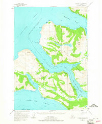 1952 Afognak A-41965 Print · USGSCoastal Alaska in the early fifties reveals a landscape of isolated maritime outposts and deep glacial bays. Trace the early layout of Port Wakefield, the remains of Port Vita (Aband), and the vital Seaplane Base along Raspberry Strait.3 unique versions available
 - 1953 Map of Afognak A-4, 1955 Print
 1953 Afognak A-41955 Print · USGSThe Afognak and Raspberry Island coastlines in the early fifties show a world of isolated maritime outposts and deep fjords. Trace the shorelines of Port Vita and Port Wakefield or locate inland features like Cloud Peak and the Lower Malina Lake system.
 - 2021 Map of Afognak A-4 SE, 2021 Print
 2021 Afognak A-4 SE2021 Print · USGSThe coastal waters and steep peaks of Kodiak Island are captured here in the early twenty-first century. Researchers can trace the layout of Port Wakefield and its relation to maritime features like Raspberry Strait and Selief Bay.
End of results
Showing maps 1-4 of 4
Top cities near Port Wakefield
Frequently asked questions
- What are the different types of historical maps available for Port Wakefield?
- What is the oldest map of Port Wakefield?
- Where can I purchase historical maps of Port Wakefield for my home or office?
- Where can I download high-res historical maps of Port Wakefield?
- Are there historical topographic maps available for Port Wakefield?
- Is there historical aerial imagery available for Port Wakefield?
- Where are historical maps of Port Wakefield sourced from?