Old Maps of Curry, Alaska for Hiking & Exploration
Hike through history with 9 historic maps of Curry. Explore old trails, ghost towns, and forgotten backroads — perfect for outdoor adventurers and local explorers.
- Rediscover forgotten places: Map out old mining camps, roads, and footpaths that no longer exist on modern maps.
- Layer with modern tools: Combine with LiDAR or satellite views to plan hikes through historical terrain.
- Made for exploration: Popular among hikers, overlanders, and local history lovers.
Use these maps to find adventure and explore the hidden past of Curry.
Curry, AK maps
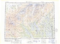
(9)- 1950 Map of Talkeetna, 1954 Print
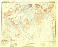
 1950 Talkeetna1954 Print · USGSThe Susitna Valley and the foothills of the Alaska Range appear in this mid-century survey as a frontier of remote lodges and rail-side outposts. You can trace the path of The Alaska Railroad through Talkeetna and locate vanished settlements like Sunflower.2 unique versions available
 - 1951 Map of Talkeetna
 1951 Talkeetna1951 Print · USGSInterior Alaska in the early fifties shows a wilderness being opened by the Alaska Railroad and bush aviation. You can trace early backcountry outposts like Chelatna Lodge, the riverside community of Talkeetna, and the high peaks of Mount Mc Kinley National Park.
 - 1951 Map of Talkeetna C-1
 1951 Talkeetna C-11951 Print · USGSThe interior of Alaska during the early fifties reveals a landscape shaped by the rail-and-river network along the Susitna River. Historians can trace the isolated outposts of Curry and McKenzie or locate the remote Airstrip and railroad markers like Mile 248.2 unique versions available
 - 1958 Map of Talkeetna C-1, 1960 Print
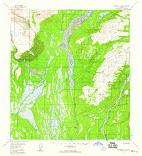 1958 Talkeetna C-11960 Print · USGSThe braided river valleys of the Matanuska-Susitna region are captured in the late fifties, showing the vital transit corridor along the Susitna River. Researchers can trace the path of the Alaska Railroad through Curry and Lane, or locate remote outposts like the Curry Lookout.5 unique versions available
 - 1958 Map of Talkeetna, 1964 Print
 1958 Talkeetna1964 Print · USGSThe Susitna Valley and Alaska Range meet in this mid-century survey of the rugged interior during a period of steady rail expansion. Historians can trace the Old Iditarod Trail, remote settlements like Collinsville, and the infrastructure of the Alaska Railroad.5 unique versions available
 - 1965 Map of Talkeetna
 1965 Talkeetna1965 Print · USGSAlaska's interior wilderness meets the steel of the Alaska Railroad during the mid-1960s. Genealogists and historians can trace remote settlements and cabins like Petersville, Collinsville, and the Sexton House tucked between the Alaska Range and the Yentna River.
 - 1987 Map of Talkeetna C-1 SE
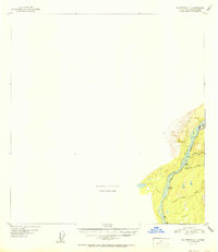
 1987 Talkeetna C-1 SE1987 Print · USGSThe Alaska rail-and-river corridor is captured here in the late eighties, showing the vital connection between wilderness and transport. Researchers can locate remote sites like Curry, the Lane (Site), and McKenzie along the tracks of The Alaska Railroad.
 - 2016 Map of Talkeetna C-1 SE, 2016 Print
 2016 Talkeetna C-1 SE2016 Print · USGSCovers Curry, including Matanuska-Susitna, United States, and other nearby areas
 - 2023 Map of Talkeetna C-1 SE, 2023 Print
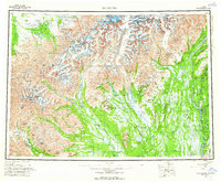
 2023 Talkeetna C-1 SE2023 Print · USGSThe Susitna Valley in the early twenty-first century reveals a landscape of river-bound settlements and essential bush airstrips. Researchers can trace the rail corridor through Curry, locate the isolated community of Chase, and find remote aviation hubs like McKinley Country Airport.
End of results
Showing maps 1-9 of 9
Frequently asked questions
- What are the different types of historical maps available for Curry?
- What is the oldest map of Curry?
- Where can I purchase historical maps of Curry for my home or office?
- Where can I download high-res historical maps of Curry?
- Are there historical topographic maps available for Curry?
- Is there historical aerial imagery available for Curry?
- Where are historical maps of Curry sourced from?