Old Maps of Eureka Roadhouse, Alaska for Genealogy
Trace your family roots with 8 historic maps of Eureka Roadhouse. These high-res maps reveal old neighborhoods, homesites, landmarks, and streets — helping you uncover where your ancestors lived and how the area evolved over time.
- Explore historic neighborhoods: Identify where your relatives may have lived in the 1800s or 1900s.
- Compare maps over time: Trace the changes in streets, buildings, and landmarks for multi-generational research.
- Perfect for genealogy & ancestry research: Used by family historians and researchers to map out lineage and migration.
These maps are an incredible resource for exploring your personal connection to Eureka Roadhouse's past.
Eureka Roadhouse, AK maps
(8)- 1948 Map of Anchorage D-1, 1967 Print
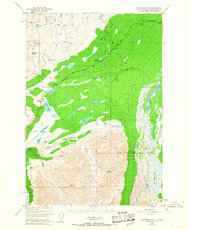 1948 Anchorage D-11967 Print · USGSThe Matanuska-Susitna region at the end of the 1940s reveals a wilderness being slowly opened by the Glenn Highway. Researchers can trace the early infrastructure of the Eureka Roadhouse and its Landing Strip alongside mountain crossings like Belanger Pass.4 unique versions available
 - 1951 Map of Anchorage
 1951 Anchorage1951 Print · USGSMid-century Anchorage and the Matanuska Valley are seen here during a period of rapid strategic growth. Trace the development of Fort Richardson, early rail stops at Wasilla, and established mining operations like the Independence Mine or Premier Mine.4 unique versions available
 - 1951 Map of Anchorage D-1, 1952 Print
 1951 Anchorage D-11952 Print · USGSThe Glenn Highway cuts through the high passes of interior Alaska at the start of the fifties. Trace early backcountry travel routes like the Tractor Trail near Eureka Roadhouse and the mountain corridor at Tahneta Pass.3 unique versions available
 - 1962 Map of Anchorage, 1966 Print
 1962 Anchorage1966 Print · USGSThe Anchorage bowl and Matanuska Valley appear in this mid-century survey during a period of significant military and industrial expansion. Researchers can trace the Alaska Railroad through Sutton and Jonesville or locate historic stops like Meekins Roadhouse and the Watertower Inn.6 unique versions available
 - 1979 Map of Anchorage, 1980 Print
 1979 Anchorage1980 Print · USGSThe Anchorage bowl and Matanuska Valley appear in the late seventies as the region's transportation and military infrastructure matured. Genealogists and historians can trace rail and road evolution through Wasilla, the Matanuska Branch line, and Jonesville.
 - 1993 Map of Anchorage D-1, 2001 Print
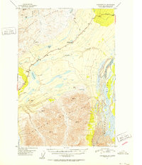
 1993 Anchorage D-12001 Print · USGSThe Glenn Highway corridor near the Matanuska River is captured here in the early nineties as a landscape of roadhouses and glacial rivers. Researchers can locate the Eureka Roadhouse, trace the terminal edge of the Nelchina Glacier, and find remote Landing Strips and Cabins.
 - 2016 Map of Anchorage D-1 NE, 2016 Print
 2016 Anchorage D-1 NE2016 Print · USGSCovers Eureka Roadhouse, including Matanuska-Susitna, United States, and other nearby areas
 - 2023 Map of Anchorage D-1 NE, 2023 Print
 2023 Anchorage D-1 NE2023 Print · USGSThe Matanuska-Susitna highlands are captured here in the early twenty-first century, showcasing a landscape of remote mountain travel. Trace the corridor of the Glenn Highway to find the Eureka Roadhouse and the nearby Skelton Airport.
End of results
Showing maps 1-8 of 8
Frequently asked questions
- What are the different types of historical maps available for Eureka Roadhouse?
- What is the oldest map of Eureka Roadhouse?
- Where can I purchase historical maps of Eureka Roadhouse for my home or office?
- Where can I download high-res historical maps of Eureka Roadhouse?
- Are there historical topographic maps available for Eureka Roadhouse?
- Is there historical aerial imagery available for Eureka Roadhouse?
- Where are historical maps of Eureka Roadhouse sourced from?