1970s Maps of Goose Bay Heights, Matanuska-Susitna
Explore 2 historic maps of Goose Bay Heights from the 1970s. These maps offer a rare glimpse into what life looked like during the 1970s — showing old roads, neighborhoods, homes, and landmarks that have changed or disappeared over time.
Whether you're researching your family's past, planning a metal detecting trip, or studying how Goose Bay Heights's landscape evolved across the 1970s, these high-resolution maps are a powerful tool for exploring the history of this region.
- Focus on a specific era: All maps on this page are from the 1970s, giving you a focused view of this time period.
- See what’s changed: Compare century-old streets, trails, and buildings to today's modern landscape using overlays and satellite layers.
- Research with precision: Use these maps for genealogy, historical research, land use analysis, or educational projects.
- View, download, or print: Maps are fully viewable online in high resolution, and can be downloaded or printed for your own records.
Start exploring Goose Bay Heights's history through authentic maps from the 1970s. This is your window into the past.
Goose Bay Heights, Matanuska-Susitna maps
(2)- 1979 Map of Anchorage, 1980 Print
 1979 Anchorage1980 Print · USGSThe Anchorage bowl and Matanuska Valley appear in the late seventies as the region's transportation and military infrastructure matured. Genealogists and historians can trace rail and road evolution through Wasilla, the Matanuska Branch line, and Jonesville.
 - 1979 Map of Anchorage B-8 NW, 1980 Print
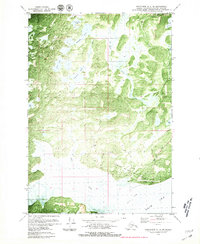 1979 Anchorage B-8 NW1980 Print · USGSThe Matanuska-Susitna coastline comes into focus in the late seventies, centered on the strategic military outpost at Goose Bay Air Force Auxiliary Field. Researchers can trace early infrastructure along Goose Bay Road and identify numerous water bodies like Sevenmile Lake and Cranberry Lake.2 unique versions available
End of results
Showing maps 1-2 of 2
Frequently asked questions
- What are the different types of historical maps available for Goose Bay Heights?
- What is the oldest map of Goose Bay Heights?
- Where can I purchase historical maps of Goose Bay Heights for my home or office?
- Where can I download high-res historical maps of Goose Bay Heights?
- Are there historical topographic maps available for Goose Bay Heights?
- Is there historical aerial imagery available for Goose Bay Heights?
- Where are historical maps of Goose Bay Heights sourced from?