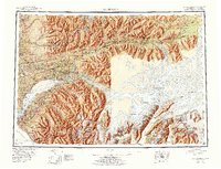
1979 Map of Anchorage
USGS Topo · Published 1980About this map
The Chugach Mountains and Talkeetna Mountains dominate this 1970s landscape, providing a dramatic backdrop for the expanding Municipality of Anchorage. The sheet captures the city's strategic importance during the late Cold War era, anchored by Elmendorf Air Force Base and the Fort Richardson Military Reservation. To the north, the growing communities of Wasilla and Palmer mark the agricultural and residential development of the Matanuska Valley, connected to the capital by the Alaska Railroad and the Glenn Highway.
Find a feature on this map
129 named features on this map. Tap any name to fly to it.
Don’t see what you’re looking for? This feature index may not catch every label — zoom into the map to look around manually.
Map Details
Editions of this 1979 Anchorage Map
This is the sole edition of this map. No revisions or reprints were ever made.
Historical Maps of Anchorage Through Time
3 maps found