Old Maps of Wasilla, Alaska for Metal Detecting
Plan your next treasure hunt with 15 historic maps of Wasilla. Find old homesites, ghost towns, trails, and gathering spots that may be lost to time — perfect for identifying promising metal detecting locations.
- Locate forgotten sites: Uncover places like long-lost settlements, abandoned rail lines, or gathering spots.
- Plan better hunts: Use map overlays combined with LiDAR or satellite views to narrow in on historically rich areas.
- Made for detectorists: Thousands of hobbyists use these maps to discover relics, coins, and hidden history.
Use these historic maps to boost your research and find new opportunities beneath the surface of Wasilla.
Wasilla, AK maps
(15)- 1950 Map of Anchorage C-7, 1963 Print
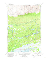 1950 Anchorage C-71963 Print · USGSWasilla and the surrounding lake country are captured here at the start of the 1950s as the rail-and-road network expanded through the Matanuska Valley. Local researchers can trace the early layout of the Alaska Railroad and find landmarks like the Thorpe Mine and Wasilla Lake.2 unique versions available
 - 1951 Map of Anchorage
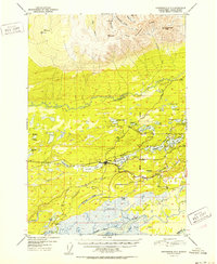
 1951 Anchorage1951 Print · USGSMid-century Anchorage and the Matanuska Valley are seen here during a period of rapid strategic growth. Trace the development of Fort Richardson, early rail stops at Wasilla, and established mining operations like the Independence Mine or Premier Mine.4 unique versions available
 - 1951 Map of Anchorage C-7, 1958 Print
 1951 Anchorage C-71958 Print · USGSThe Matanuska Valley center of Wasilla is captured here in the early fifties, just as post-war infrastructure began to define the region. You can trace the path of The Alaska Railroad and find early homestead landmarks like Lucile Lake, Paradise Lake, and Fishhook Road.
 - 1952 Map of Anchorage C-7
 1952 Anchorage C-71952 Print · USGSThe Matanuska Valley was in a period of early post-war expansion in the 1950s, centered on the growing rail hub of Wasilla. Researchers can trace the early road network and remote landmarks like the Thorpe Mine, The Alaska Railroad, and Finger Lake.2 unique versions available
 - 1962 Map of Anchorage, 1966 Print
 1962 Anchorage1966 Print · USGSThe Anchorage bowl and Matanuska Valley appear in this mid-century survey during a period of significant military and industrial expansion. Researchers can trace the Alaska Railroad through Sutton and Jonesville or locate historic stops like Meekins Roadhouse and the Watertower Inn.6 unique versions available
 - 1979 Map of Anchorage, 1980 Print
 1979 Anchorage1980 Print · USGSThe Anchorage bowl and Matanuska Valley appear in the late seventies as the region's transportation and military infrastructure matured. Genealogists and historians can trace rail and road evolution through Wasilla, the Matanuska Branch line, and Jonesville.
 - 1979 Map of Anchorage C-7 SE, 1980 Print
 1979 Anchorage C-7 SE1980 Print · USGSWasilla and the surrounding Matanuska-Susitna Valley are captured during a period of transition in the late seventies as local infrastructure expanded. Researchers can trace the development of the Alaska Railroad corridor, the Iditarod School, and the University of Alaska Experimental Farm.
 - 1979 Map of Anchorage C-7 SW, 1980 Print
 1979 Anchorage C-7 SW1980 Print · USGSWasilla and the surrounding lake country were experiencing steady growth in the late seventies as transportation and local services expanded. Genealogists and historians can trace the early layout of Wasilla, the path of The Alaska Railroad, and the location of Iditarod Sch.
 - 1992 Map of Anchorage C-7 SE
 1992 Anchorage C-7 SE1992 Print · USGSWasilla and its surrounding lakes are captured during a period of significant growth in the early nineties. Genealogists and local historians can locate established institutions like Iditarod Sch, the University of Alaska Experimental Farm, and the shoreline of Finger Lake.
 - 1992 Map of Anchorage C-7 SW
 1992 Anchorage C-7 SW1992 Print · USGSWasilla and the surrounding Matanuska-Susitna Valley are captured here during a decade of rapid growth in the early nineties. Genealogists and researchers can trace local landmarks like Iditarod Sch, Lake Lucile, and the sprawling Palmer Hay Flats.
 - 1994 Map of Anchorage C-7, 2002 Print
 1994 Anchorage C-72002 Print · USGSThe Matanuska-Susitna Valley comes into focus in the 1990s as the community of Wasilla expands along its lake-strewn corridor. Genealogists and local historians can trace the development of the Alaska Railroad, the Iditarod Trail, and local landmarks like Snowshoe School.
 - 2016 Map of Anchorage C-7 SE, 2016 Print
 2016 Anchorage C-7 SE2016 Print · USGSCovers Wasilla, including Matanuska-Susitna, United States, and other nearby areas
 - 2016 Map of Anchorage C-7 SW, 2016 Print
 2016 Anchorage C-7 SW2016 Print · USGSCovers Wasilla, including Meadow Lakes, Cottonwood, and other nearby areas
 - 2023 Map of Anchorage C-7 SE, 2023 Print
 2023 Anchorage C-7 SE2023 Print · USGSThe Matanuska Valley area in the 2020s shows a landscape defined by rapid residential growth and private aviation. Trace the Alaska Railroad as it passes Wasilla Lake or locate local landmarks like Wasilla Cem and Gattis Strip.
 - 2023 Map of Anchorage C-7 SW, 2023 Print
 2023 Anchorage C-7 SW2023 Print · USGSThe Matanuska Valley flourishes in the early twenty-first century as a hub of rail, aviation, and lakeside community life. Genealogists and researchers can trace local family landmarks at Sacred Heart Catholic Cem and Wasilla Airport.
End of results
Showing maps 1-15 of 15
Frequently asked questions
- What are the different types of historical maps available for Wasilla?
- What is the oldest map of Wasilla?
- Where can I purchase historical maps of Wasilla for my home or office?
- Where can I download high-res historical maps of Wasilla?
- Are there historical topographic maps available for Wasilla?
- Is there historical aerial imagery available for Wasilla?
- Where are historical maps of Wasilla sourced from?