Old Maps of Chariot, Alaska
Explore 5 old maps of Chariot, spanning from 1952 to today. These high-resolution historic maps reveal how streets, neighborhoods, landmarks, and natural features evolved over time — perfect for genealogy, metal detecting, research, and local history exploration.
What you can do with these maps:
- See how Chariot changed over time: Compare historical maps to modern-day views to trace roads, homesites, rail lines & more.
- View detailed metadata: Each map includes creators, publishers, year, scale, and archive source.
- Overlay maps with satellite & LiDAR: Visualize the past alongside modern tools to explore terrain & human change.
- Trusted historical sources: Maps sourced from the USGS, Library of Congress, and other archives.
- Access maps your way: View online, download high-res files, or order prints for personal or research use.
Start exploring old maps of Chariot to uncover forgotten places, hidden landmarks, and the deep history beneath your feet.
Chariot, AK maps
(5)- 1952 Map of Point Hope, 1953 Print
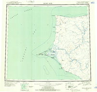 1952 Point Hope1953 Print · USGSCoastal Alaska at the mid-century shows a sparse but vital network of Arctic settlements and resource extraction points. Researchers can trace the Winter Trail past Wevok to the Corwin Mine or locate the Cem near the Point Hope village.
 - 1952 Map of Point Hope A-2, 1958 Print
 1952 Point Hope A-21958 Print · USGSThe northern Alaskan coast of the early fifties is captured here before modern development. Researchers can locate coastal Ruins and trace the drainage of Ahgahyoukuk Creek as it flows past Ahgahyoukuk Mtn toward the Chukchi Sea.4 unique versions available
 - 1955 Map of Point Hope, 1964 Print
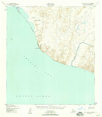
 1955 Point Hope1964 Print · USGSCoastal Alaska at the edge of the Arctic comes into focus in this mid-century survey of the Chukchi Sea coastline. Genealogists and researchers can trace the locations of Point Hope, the Jabbertown site, and the remote Corwin Mine and Chariot settlements.3 unique versions available
 - 1965 Map of Point Hope
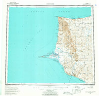
 1965 Point Hope1965 Print · USGSCoastal North Slope Alaska is captured in the mid-1960s, showing the intersection of remote settlements and military-era infrastructure. Genealogists and historians can trace the Winter Trail, the remains of Jabbertown, and numerous historical sites like Kukpuk.
 - 2014 Map of Point Hope A-2 SE, 2014 Print
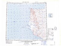
 2014 Point Hope A-2 SE2014 Print · USGSThe coastal North Slope Borough is captured here in the early twenty-first century as the land transitions into the Chukchi Sea. Researchers can trace the unique coastal features of Chariot, including the heights of Iluituk Hill and the waters of Ogotoruk Cr.
End of results
Showing maps 1-5 of 5
Frequently asked questions
- What are the different types of historical maps available for Chariot?
- What is the oldest map of Chariot?
- Where can I purchase historical maps of Chariot for my home or office?
- Where can I download high-res historical maps of Chariot?
- Are there historical topographic maps available for Chariot?
- Is there historical aerial imagery available for Chariot?
- Where are historical maps of Chariot sourced from?