1952 Map of Point Hope
USGS Topo · Published 1953About this map
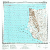
Point Hope extends into the Chukchi Sea on this reconnaissance survey, serving as a primary hub for this remote stretch of the Arctic coast. The landscape is defined by the dramatic coastal formations of the Lisburne Hills, where elevations rise sharply toward Mt Hamlet and drop into the sea at Cape Lisburne. A critical Winter Trail connects the western tip of the peninsula to the far northeastern corner of the map, passing near the Corwin Mine at Corwin Bluff. Historical sites including the settlement of Tuckfield and the abandoned village of Wevok are documented alongside navigational aids like the Point Hope Light. The drainage systems of the Kukpuk River and Ipewik River dominate the interior, illustrating the complex hydrology of the tundra before it reaches the Marryatt Inlet.
Find a feature on this map
41 named features on this map. Tap any name to fly to it.
Don’t see what you’re looking for? This feature index may not catch every label — zoom into the map to look around manually.
Map Details
Editions of this 1952 Point Hope Map
This is the sole edition of this map. No revisions or reprints were ever made.
Historical Maps of Point Hope Through Time
3 maps found