Old Maps of Deadhorse, Alaska for Academic Research
Study the evolution of Deadhorse with 7 high-resolution historic maps. Whether you're teaching, researching, or modeling changes in land use, these maps provide essential visual documentation of urban, environmental, and geographic change.
- Analyze long-term change: Track patterns in development, transportation, and natural features.
- Ideal for environmental or urban studies: Support academic projects with primary historical map data.
- Use in the classroom or lab: Educators and researchers rely on these maps to bring historical context to life.
These maps are a powerful tool for teaching, research, and visualizing how Deadhorse has changed over the decades.
Deadhorse, AK maps
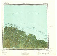
(7)- 1951 Map of Beechey Point
 1951 Beechey Point1951 Print · USGSThe North Slope coast is captured here just after the war, showing the wild river deltas and barrier islands of the Arctic. Trace the natural flow of the Sagavanirktok River and locate coastal landmarks like Beechey Point and Prudhoe Bay before their industrial transformation.
 - 1955 Map of Beechey Point, 1961 Print
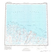
 1955 Beechey Point1961 Print · USGSThe Arctic coastline of the North Slope appears here in the mid-fifties, years before industrial oil development reshaped the landscape. Researchers can trace the original paths of the Kuparuk River and Sagavanirktok River or locate coastal outposts like Beechey Point and remote cabins.5 unique versions available
 - 1955 Map of Beechey Point A-3, 1969 Print
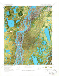
 1955 Beechey Point A-31969 Print · USGSThe Arctic coastal plain appears as a labyrinth of water and tundra in the mid-fifties, years before the discovery of oil nearby. Researchers can trace the shifting braided channels of the Sagavanirktok River and the winding course of the Putuligayuk River.3 unique versions available
 - 1960 Map of Beechey Point, 1977 Print
 1960 Beechey Point1977 Print · USGSThe Alaska North Slope emerges in this mid-century survey as industrial infrastructure begins to take hold along the Arctic coast. Researchers can trace early developments at Deadhorse and Prudhoe Bay or locate remote coastal points like Beechey Point.3 unique versions available
 - 1964 Map of Beechey Point
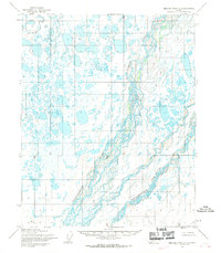
 1964 Beechey Point1964 Print · USGSThe North Slope coast and Prudhoe Bay are documented in the mid-sixties, years before the regional oil boom. Researchers can trace the original paths of the Sagavanirktok River and Kuparik River or locate remote coastal cabins and the McClure Islands.
 - 1970 Map of Beechey Point A-3 NE, 1971 Print
 1970 Beechey Point A-3 NE1971 Print · USGSThe Arctic coast was undergoing a massive industrial transformation in the early seventies as energy exploration took hold. Researchers can trace the layout of early oil field infrastructure including Deadhorse, Halliburton Camp, and the Winter Trail.2 unique versions available
 - 2017 Map of Beechey Point A-3 NE, 2017 Print
 2017 Beechey Point A-3 NE2017 Print · USGSThe Arctic industrial landscape at the end of the road comes to life in this 2017 survey of the North Slope. Trace the infrastructure of Prudhoe Bay and Deadhorse, from the Deadhorse Airport to the northern reaches of the Dalton Highway.
End of results
Showing maps 1-7 of 7
Top cities near Deadhorse
Frequently asked questions
- What are the different types of historical maps available for Deadhorse?
- What is the oldest map of Deadhorse?
- Where can I purchase historical maps of Deadhorse for my home or office?
- Where can I download high-res historical maps of Deadhorse?
- Are there historical topographic maps available for Deadhorse?
- Is there historical aerial imagery available for Deadhorse?
- Where are historical maps of Deadhorse sourced from?