1960s Maps of Northwest Arctic, Alaska
Explore 14 historic maps of Northwest Arctic from the 1960s. These maps offer a rare glimpse into what life looked like during the 1960s — showing old roads, neighborhoods, homes, and landmarks that have changed or disappeared over time.
Whether you're researching your family's past, planning a metal detecting trip, or studying how Northwest Arctic's landscape evolved across the 1960s, these high-resolution maps are a powerful tool for exploring the history of this region.
- Focus on a specific era: All maps on this page are from the 1960s, giving you a focused view of this time period.
- See what’s changed: Compare century-old streets, trails, and buildings to today's modern landscape using overlays and satellite layers.
- Research with precision: Use these maps for genealogy, historical research, land use analysis, or educational projects.
- View, download, or print: Maps are fully viewable online in high resolution, and can be downloaded or printed for your own records.
Start exploring Northwest Arctic's history through authentic maps from the 1960s. This is your window into the past.
Northwest Arctic, AK maps
(14)- 1964 Map of Noatak
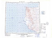
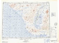 1964 Noatak1964 Print · USGSCoastal life in Northwest Arctic Alaska was centered on the river mouths and lagoons of the Chukchi Sea during the mid-1960s. Researchers can trace the Winter Trail connecting Kivalina to the interior and locate the remote landing area at Cape Krusenstern.
 - 1964 Map of Survey Pass
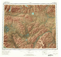
 1964 Survey Pass1964 Print · USGSThe Brooks Range remains a wilderness of massive peaks and headwaters in the mid-1960s. Map collectors and researchers can trace drainage divides at Survey Pass and locate landmarks like the Arrigetch Peaks or Walker Lake.
 - 1964 Map of Shungnak
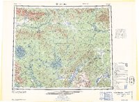
 1964 Shungnak1964 Print · USGSNorthwest Alaska in the mid-sixties is mapped here across the wild watersheds of the Kobuk River and Selawik River. Researchers can locate isolated settlements like Shungnak and Kobuk, or trace the path of the Arctic Circle through the Lockwood Hills.
 - 1964 Map of Bendeleben
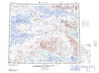
 1964 Bendeleben1964 Print · USGSThe central Seward Peninsula comes into focus in the 1950s, showing a landscape of volcanic cones, river systems, and mining outposts. Trace the history of remote settlements like Taylor and Dahl or locate seasonal cabins near Imuruk Lake and Death Valley.
 - 1964 Map of Hughes
 1964 Hughes1964 Print · USGSThe Arctic Circle crosses this interior Alaskan wilderness in the mid-1960s, a period when the river was the primary lifeline. Genealogists and researchers can trace remote settlements and routes like Hughes, the Potziligi Portage, and several scattered Cabins.
 - 1964 Map of Kotzebue
 1964 Kotzebue1964 Print · USGSThe Northwest Arctic coast during the mid-sixties reveals a landscape of isolated seasonal trails and maritime outposts. Researchers can trace the Winter Trail across the tundra to settlements like Deering, Kotzebue, and Singreak.
 - 1964 Map of Candle
 1964 Candle1964 Print · USGSRemote outposts and gold-bearing creeks mark the Northwest Arctic during the mid-1960s, a time of transition for the Seward Peninsula. You can trace early overland travel along the Tractor Trail or locate vanished mining sites at Haycock and Dime Landing.
 - 1964 Map of Ambler River
 1964 Ambler River1964 Print · USGSAlaska's northern interior during the mid-1960s reveals a wilderness of high peaks and river corridors where miners and trappers left their mark. Trace early prospecting sites near Asbestos Mountain and navigate the Great Kobuk Sand Dunes or Ivishak Pass.
 - 1965 Map of Baird Mountains
 1965 Baird Mountains1965 Print · USGSThe Northwest Arctic wilderness is captured here in the mid-fifties, showing the vast drainages of the Noatak and Kobuk rivers. Researchers can trace remote landmarks like the Klery Creek Landing Strip, the Grand Canyon, and Sekuak Bluff.
 - 1965 Map of Point Hope
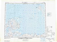
 1965 Point Hope1965 Print · USGSCoastal North Slope Alaska is captured in the mid-1960s, showing the intersection of remote settlements and military-era infrastructure. Genealogists and historians can trace the Winter Trail, the remains of Jabbertown, and numerous historical sites like Kukpuk.
 - 1965 Map of De Long Mountains
 1965 De Long Mountains1965 Print · USGSThe northern Alaskan wilderness is captured here in the mid-1960s, showing the high peaks of the De Long Mountains and the coastal tundra. Researchers can trace the path of the Winter Trail and locate the Thetis Mine near the Chukchi Sea coastline.
 - 1965 Map of Hughes, 1966 Print
 1965 Hughes1966 Print · USGSThe Alaskan interior during the mid-1960s reveals a wilderness organized by river travel and remote outposts. Researchers can trace historic transit corridors like the Sled Trail and Potzitigi Portage, or locate the Cem and airstrips at Hughes.
 - 1966 Map of Ambler River A-4, 1967 Print
 1966 Ambler River A-41967 Print · USGSAmbler and its surrounding river valleys are captured here in the mid-sixties, showing the intersection of the Kobuk and Ambler rivers. Researchers can locate remote Cabins, trace the path of the Winter Trail, and see the high peaks of the Jade Mountains.
 - 1966 Map of Survey Pass, 1967 Print
 1966 Survey Pass1967 Print · USGSThe central Brooks Range remains a roadless wilderness in the mid-1960s, centered on the high peaks of the CONTINENTAL DIVIDE. Researchers can trace historic travel routes through Survey Pass or locate remote landmarks like the Alatna Portage and Walker Lake.
End of results
Showing maps 1-14 of 14
Top cities of Northwest Arctic
- Kotzebue historical maps
- Selawik historical maps
- Noorvik historical maps
- Noatak historical maps
- Buckland historical maps
- Kiana historical maps
See more
Frequently asked questions
- What are the different types of historical maps available for Northwest Arctic?
- What is the oldest map of Northwest Arctic?
- Where can I purchase historical maps of Northwest Arctic for my home or office?
- Where can I download high-res historical maps of Northwest Arctic?
- Are there historical topographic maps available for Northwest Arctic?
- Is there historical aerial imagery available for Northwest Arctic?
- Where are historical maps of Northwest Arctic sourced from?