Old Maps of Ambler, Alaska for Hiking & Exploration
Hike through history with 6 historic maps of Ambler. Explore old trails, ghost towns, and forgotten backroads — perfect for outdoor adventurers and local explorers.
- Rediscover forgotten places: Map out old mining camps, roads, and footpaths that no longer exist on modern maps.
- Layer with modern tools: Combine with LiDAR or satellite views to plan hikes through historical terrain.
- Made for exploration: Popular among hikers, overlanders, and local history lovers.
Use these maps to find adventure and explore the hidden past of Ambler.
Ambler, AK maps
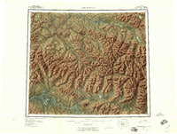
(6)- 1951 Map of Ambler River, 1952 Print
 1951 Ambler River1952 Print · USGSThe northern Alaskan wilderness is mapped here in the early post-war era as aerial photography began to reveal the Brooks Range in detail. Researchers can trace the path of the Winter Trail and locate isolated outposts like the Pitka Shelter Cabin and various cabins along the Kobuk River.
 - 1955 Map of Ambler River A-4, 1959 Print
 1955 Ambler River A-41959 Print · USGSThe Northwest Arctic wilderness is captured here in the mid-twentieth century, dominated by the winding Kobuk River. Genealogists and historians can locate remote Cabins and trace the drainage of Pitkik Lake and the Jade Mountains.
 - 1956 Map of Ambler River, 1959 Print
 1956 Ambler River1959 Print · USGSNorthern Alaska's interior remains a landscape of geological extremes in the mid-1950s. Trace the isolated Kobuk River valley to find Onion Portage, the towering Great Kobuk Sand Dunes, and mining sites near Asbestos Mountain.6 unique versions available
 - 1964 Map of Ambler River
 1964 Ambler River1964 Print · USGSAlaska's northern interior during the mid-1960s reveals a wilderness of high peaks and river corridors where miners and trappers left their mark. Trace early prospecting sites near Asbestos Mountain and navigate the Great Kobuk Sand Dunes or Ivishak Pass.
 - 1966 Map of Ambler River A-4, 1967 Print
 1966 Ambler River A-41967 Print · USGSAmbler and its surrounding river valleys are captured here in the mid-sixties, showing the intersection of the Kobuk and Ambler rivers. Researchers can locate remote Cabins, trace the path of the Winter Trail, and see the high peaks of the Jade Mountains.
 - 2015 Map of Ambler River A-4 SW, 2015 Print
 2015 Ambler River A-4 SW2015 Print · USGSAmbler and its surrounding river systems are captured in detail during the mid-2010s. Researchers can trace the local street grid including Waring Street and the layout of the Ambler Airport near the junction of the Ambler River and Kobuk River.
End of results
Showing maps 1-6 of 6
Frequently asked questions
- What are the different types of historical maps available for Ambler?
- What is the oldest map of Ambler?
- Where can I purchase historical maps of Ambler for my home or office?
- Where can I download high-res historical maps of Ambler?
- Are there historical topographic maps available for Ambler?
- Is there historical aerial imagery available for Ambler?
- Where are historical maps of Ambler sourced from?