Old Maps of Bornite, Alaska for Metal Detecting
Plan your next treasure hunt with 5 historic maps of Bornite. Find old homesites, ghost towns, trails, and gathering spots that may be lost to time — perfect for identifying promising metal detecting locations.
- Locate forgotten sites: Uncover places like long-lost settlements, abandoned rail lines, or gathering spots.
- Plan better hunts: Use map overlays combined with LiDAR or satellite views to narrow in on historically rich areas.
- Made for detectorists: Thousands of hobbyists use these maps to discover relics, coins, and hidden history.
Use these historic maps to boost your research and find new opportunities beneath the surface of Bornite.
Bornite, AK maps
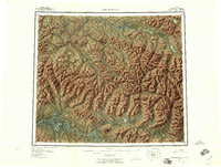
(5)- 1951 Map of Ambler River, 1952 Print
 1951 Ambler River1952 Print · USGSThe northern Alaskan wilderness is mapped here in the early post-war era as aerial photography began to reveal the Brooks Range in detail. Researchers can trace the path of the Winter Trail and locate isolated outposts like the Pitka Shelter Cabin and various cabins along the Kobuk River.
 - 1956 Map of Ambler River, 1959 Print
 1956 Ambler River1959 Print · USGSNorthern Alaska's interior remains a landscape of geological extremes in the mid-1950s. Trace the isolated Kobuk River valley to find Onion Portage, the towering Great Kobuk Sand Dunes, and mining sites near Asbestos Mountain.6 unique versions available
 - 1964 Map of Ambler River
 1964 Ambler River1964 Print · USGSAlaska's northern interior during the mid-1960s reveals a wilderness of high peaks and river corridors where miners and trappers left their mark. Trace early prospecting sites near Asbestos Mountain and navigate the Great Kobuk Sand Dunes or Ivishak Pass.
 - 1985 Map of Ambler River A-2
 1985 Ambler River A-21985 Print · USGSRemote northwestern Alaska is documented here during the mid-eighties, showing the intersection of mountainous terrain and river lowlands. Researchers can trace the path of the Tractor Trail near Bornite or follow the courses of the Ambler River and Shungnak River.
 - 2016 Map of Ambler River A-2 SW, 2016 Print
 2016 Ambler River A-2 SW2016 Print · USGSNorthern Alaskan mining history and the rugged Cosmos Hills come alive in this 2016 survey. Researchers can trace the remote settlement of Bornite and the surrounding peaks of Iron Mtn and Bannock Mtn.
End of results
Showing maps 1-5 of 5
Top cities near Bornite
Frequently asked questions
- What are the different types of historical maps available for Bornite?
- What is the oldest map of Bornite?
- Where can I purchase historical maps of Bornite for my home or office?
- Where can I download high-res historical maps of Bornite?
- Are there historical topographic maps available for Bornite?
- Is there historical aerial imagery available for Bornite?
- Where are historical maps of Bornite sourced from?