Old Maps of Fink Creek, Alaska for Hiking & Exploration
Hike through history with 5 historic maps of Fink Creek. Explore old trails, ghost towns, and forgotten backroads — perfect for outdoor adventurers and local explorers.
- Rediscover forgotten places: Map out old mining camps, roads, and footpaths that no longer exist on modern maps.
- Layer with modern tools: Combine with LiDAR or satellite views to plan hikes through historical terrain.
- Made for exploration: Popular among hikers, overlanders, and local history lovers.
Use these maps to find adventure and explore the hidden past of Fink Creek.
Fink Creek, AK maps
(5)- 1950 Map of Bendeleben, 1956 Print
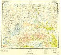 1950 Bendeleben1956 Print · USGSThe Seward Peninsula in the early fifties shows a rugged interior reliant on aviation and gold mining. Researchers can trace remote outposts like Bunker Hill Station and Aurora or find landing strips at Utica Landing Area.6 unique versions available
 - 1950 Map of Bendeleben D-3, 1956 Print
 1950 Bendeleben D-31956 Print · USGSThe Seward Peninsula in the early fifties reveals a landscape shaped by remote mineral interests and glacial topography. Researchers can trace the path of the Fairhaven Ditch and locate the Gold Mine near Hannum Creek.2 unique versions available
 - 1951 Map of Bendeleben
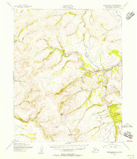
 1951 Bendeleben1951 Print · USGSThe central Seward Peninsula in the early fifties was a rugged frontier of isolated mining outposts and volcanic fields. Researchers can trace the path of the Railroad (Abandoned) and locate early settlements like Noxapaga, Aurora, and Shelton.2 unique versions available
 - 1964 Map of Bendeleben
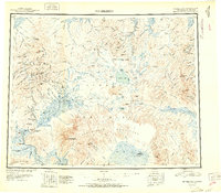
 1964 Bendeleben1964 Print · USGSThe central Seward Peninsula comes into focus in the 1950s, showing a landscape of volcanic cones, river systems, and mining outposts. Trace the history of remote settlements like Taylor and Dahl or locate seasonal cabins near Imuruk Lake and Death Valley.
 - 2017 Map of Bendeleben D-3 NE, 2017 Print
 2017 Bendeleben D-3 NE2017 Print · USGSThe Seward Peninsula is captured here in the late twenty-first century, showing the remote northern reaches of the Bering Land Bridge National Preserve. Researchers can trace the path of the Deering Road as it winds past Logan Gulch and the Inmachuk River.
End of results
Showing maps 1-5 of 5
Top cities near Fink Creek
Frequently asked questions
- What are the different types of historical maps available for Fink Creek?
- What is the oldest map of Fink Creek?
- Where can I purchase historical maps of Fink Creek for my home or office?
- Where can I download high-res historical maps of Fink Creek?
- Are there historical topographic maps available for Fink Creek?
- Is there historical aerial imagery available for Fink Creek?
- Where are historical maps of Fink Creek sourced from?