Old Maps of Noatak Heights, Noatak
Explore 5 old maps of Noatak Heights, spanning from 1951 to today. These high-resolution historic maps reveal how streets, neighborhoods, landmarks, and natural features evolved over time — perfect for genealogy, metal detecting, research, and local history exploration.
What you can do with these maps:
- See how Noatak Heights changed over time: Compare historical maps to modern-day views to trace roads, homesites, rail lines & more.
- View detailed metadata: Each map includes creators, publishers, year, scale, and archive source.
- Overlay maps with satellite & LiDAR: Visualize the past alongside modern tools to explore terrain & human change.
- Trusted historical sources: Maps sourced from the USGS, Library of Congress, and other archives.
- Access maps your way: View online, download high-res files, or order prints for personal or research use.
Start exploring old maps of Noatak Heights to uncover forgotten places, hidden landmarks, and the deep history beneath your feet.
Noatak Heights, Noatak maps
(5)- 1951 Map of Noatak
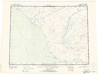 1951 Noatak1951 Print · USGSThe Arctic coast and interior river valleys of northwest Alaska are detailed here in the early fifties. Researchers can trace the path of the Winter Trail and locate remote outposts like Tikizat and various Cabins along the Noatak River.2 unique versions available
 - 1955 Map of Noatak, 1962 Print
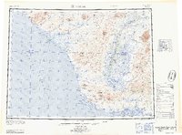
 1955 Noatak1962 Print · USGSThe Northwest Arctic coast and Noatak River valley are shown here in the mid-1950s, detailing a landscape of vast lagoons and high peaks. Genealogists and researchers can trace the footings of Kivalina and Noatak, or follow the Winter Trail past Cape Krusenstern.7 unique versions available
 - 1955 Map of Noatak C-2, 1969 Print
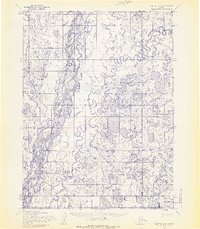 1955 Noatak C-21969 Print · USGSIn the mid-1950s, the remote settlement of Noatak stood as a vital outpost along the braided channels of the Noatak River. Researchers can trace the early layout of the village and its essential Landing Strip near the confluence of the Eli River.3 unique versions available
 - 1964 Map of Noatak
 1964 Noatak1964 Print · USGSCoastal life in Northwest Arctic Alaska was centered on the river mouths and lagoons of the Chukchi Sea during the mid-1960s. Researchers can trace the Winter Trail connecting Kivalina to the interior and locate the remote landing area at Cape Krusenstern.
 - 2015 Map of Noatak C-2 SW, 2015 Print
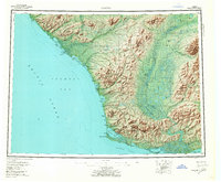
 2015 Noatak C-2 SW2015 Print · USGSNoatak and the surrounding Arctic tundra are captured here in the mid-2010s, centered on the confluence of the Noatak River and Eli River. Researchers can trace the village street plan including Main Street and the proximity of the Noatak Airport.
End of results
Showing maps 1-5 of 5
Frequently asked questions
- What are the different types of historical maps available for Noatak Heights?
- What is the oldest map of Noatak Heights?
- Where can I purchase historical maps of Noatak Heights for my home or office?
- Where can I download high-res historical maps of Noatak Heights?
- Are there historical topographic maps available for Noatak Heights?
- Is there historical aerial imagery available for Noatak Heights?
- Where are historical maps of Noatak Heights sourced from?