Old Maps of Selawik, Alaska for Hiking & Exploration
Hike through history with 6 historic maps of Selawik. Explore old trails, ghost towns, and forgotten backroads — perfect for outdoor adventurers and local explorers.
- Rediscover forgotten places: Map out old mining camps, roads, and footpaths that no longer exist on modern maps.
- Layer with modern tools: Combine with LiDAR or satellite views to plan hikes through historical terrain.
- Made for exploration: Popular among hikers, overlanders, and local history lovers.
Use these maps to find adventure and explore the hidden past of Selawik.
Selawik, AK maps
(6)- 1951 Map of Selawik
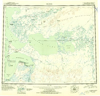 1951 Selawik1951 Print · USGSThe Arctic landscape of the early 1950s unfolds across this survey of the Kobuk River delta and the vast inland waters. Researchers can trace remote outposts and infrastructure like the Okok Trading Post, Reindeer Station, and several Winter Trails.
 - 1955 Map of Selawik C-3, 1968 Print
 1955 Selawik C-31968 Print · USGSNorthwest Arctic Alaska in the mid-1950s reveals a vast river delta system where the Selawik River meets the sea. Researchers can trace the layout of Selawik, locate the Landing Strip, and follow the Winter Trail through the tundra.
 - 1957 Map of Selawik, 1961 Print
 1957 Selawik1961 Print · USGSNorthwest Arctic Alaska in the late fifties reveals a vast network of delta channels and isolated outposts above the Arctic Circle. Genealogists and historians can trace traditional locations like Noorvik and Kiana or remote landmarks such as the Reindeer Corral Cabin.7 unique versions available
 - 1985 Map of Selawik C-2
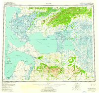
 1985 Selawik C-21985 Print · USGSThe Northwest Arctic coast in the mid-eighties was a wilderness of shifting delta waters and established native sites. Researchers can trace the intricate river systems around Selawik, including the Selawik River, Inland Lake, and Fish River.
 - 2016 Map of Selawik C-2 SW, 2016 Print
 2016 Selawik C-2 SW2016 Print · USGSLife in the Northwest Arctic centered on the river during the early twenty-first century. Researchers can trace the layout of Selawik and its vital connections to Inland Lake, the Selawik Airport, and the winding Selawik River.
 - 2016 Map of Selawik C-3 SE, 2016 Print
 2016 Selawik C-3 SE2016 Print · USGSIn the Alaska-Northwest Arctic Borough, the village of Selawik stands as a focal point among a maze of Arctic waterways. Genealogists and researchers can trace the local street grid near the Selawik River or study the shorelines of Selawik Lake and Inland Lake.
End of results
Showing maps 1-6 of 6
Frequently asked questions
- What are the different types of historical maps available for Selawik?
- What is the oldest map of Selawik?
- Where can I purchase historical maps of Selawik for my home or office?
- Where can I download high-res historical maps of Selawik?
- Are there historical topographic maps available for Selawik?
- Is there historical aerial imagery available for Selawik?
- Where are historical maps of Selawik sourced from?