1940s Maps of Craig, Alaska
Explore 2 historic maps of Craig from the 1940s. These maps offer a rare glimpse into what life looked like during the 1940s — showing old roads, neighborhoods, homes, and landmarks that have changed or disappeared over time.
Whether you're researching your family's past, planning a metal detecting trip, or studying how Craig's landscape evolved across the 1940s, these high-resolution maps are a powerful tool for exploring the history of this region.
- Focus on a specific era: All maps on this page are from the 1940s, giving you a focused view of this time period.
- See what’s changed: Compare century-old streets, trails, and buildings to today's modern landscape using overlays and satellite layers.
- Research with precision: Use these maps for genealogy, historical research, land use analysis, or educational projects.
- View, download, or print: Maps are fully viewable online in high resolution, and can be downloaded or printed for your own records.
Start exploring Craig's history through authentic maps from the 1940s. This is your window into the past.
Craig, AK maps
(2)- 1949 Map of Craig C-4, 1964 Print
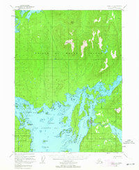 1949 Craig C-41964 Print · USGSThe maritime heart of Prince of Wales Island comes alive in this post-war survey of its intricate coastline and timbered peaks. Researchers can trace historic access points around Klawak Harbor, local cemeteries, and landmarks like Big Salt Lake and Staney Cone.5 unique versions available
 - 1949 Map of Craig B-4, 1975 Print
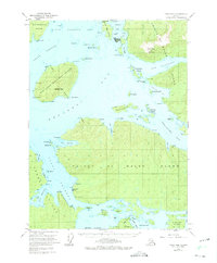 1949 Craig B-41975 Print · USGSCoastal life on Prince of Wales Island comes into focus here during the late 1940s, highlighting the region's fishing and maritime foundations. Researchers can trace the layout of Craig and Klawock, find the Indian Village, and locate the Waterfall Cannery along the Ulloa Channel.2 unique versions available
End of results
Showing maps 1-2 of 2
Top cities near Craig
Frequently asked questions
- What are the different types of historical maps available for Craig?
- What is the oldest map of Craig?
- Where can I purchase historical maps of Craig for my home or office?
- Where can I download high-res historical maps of Craig?
- Are there historical topographic maps available for Craig?
- Is there historical aerial imagery available for Craig?
- Where are historical maps of Craig sourced from?