1900s (20th Century) Maps of Labouchere Bay, Alaska
Explore 5 historic maps of Labouchere Bay from the 1900s (20th Century). These maps offer a rare glimpse into what life looked like during the 1900s — showing old roads, neighborhoods, homes, and landmarks that have changed or disappeared over time.
Whether you're researching your family's past, planning a metal detecting trip, or studying how Labouchere Bay's landscape evolved across the 1900s, these high-resolution maps are a powerful tool for exploring the history of this region.
- Focus on a specific era: All maps on this page are from the 1900s, giving you a focused view of this time period.
- See what’s changed: Compare century-old streets, trails, and buildings to today's modern landscape using overlays and satellite layers.
- Research with precision: Use these maps for genealogy, historical research, land use analysis, or educational projects.
- View, download, or print: Maps are fully viewable online in high resolution, and can be downloaded or printed for your own records.
Start exploring Labouchere Bay's history through authentic maps from the 1900s. This is your window into the past.
Labouchere Bay, AK maps
(5)- 1949 Map of Petersburg B-5, 1963 Print
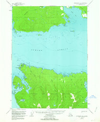 1949 Petersburg B-51963 Print · USGSPrince of Wales and Kupreanof Islands are shown in the mid-twentieth century as maritime life centers on these intricate straits. Trace old coastal activity at the Trading Post near Point Baker and explore the waters of Port Protection.3 unique versions available
 - 1952 Map of Petersburg, 1953 Print
 1952 Petersburg1953 Print · USGSSoutheast Alaska's intricate Alexander Archipelago comes to life in the early fifties, documenting a landscape of remote island settlements and maritime corridors. Genealogists and historians can trace coastal life in Petersburg and Wrangell, or locate early industry at Shakan and regional Mines.5 unique versions available
 - 1953 Map of Petersburg B-5, 1954 Print
 1953 Petersburg B-51954 Print · USGSThe Alexander Archipelago in the early fifties reveals a landscape of isolated maritime outposts and deep coastal inlets. Researchers can trace the early layout of Point Baker and find historic sites like the Trading Post at Wooden Wheel Cove and Port Protection.2 unique versions available
 - 1960 Map of Petersburg, 1966 Print
 1960 Petersburg1966 Print · USGSSoutheast Alaska's maritime landscape is captured here in the mid-1900s, showcasing the intricate island networks of the Alexander Archipelago. Researchers can trace historic shorelines and island settlements from Petersburg and Kake to the Wrangell Cemetery and the Stikine River.3 unique versions available
 - 1995 Map of Petersburg B-5, 1999 Print
 1995 Petersburg B-51999 Print · USGSPrince of Wales Island and Kupreanof Island are shown in the mid-nineties during a period of active timber management and coastal settlement. Researchers can trace the layout of the Logging Camp and Log Transfer Facility near Port Protection and the small harbor at Point Baker.
End of results
Showing maps 1-5 of 5
Frequently asked questions
- What are the different types of historical maps available for Labouchere Bay?
- What is the oldest map of Labouchere Bay?
- Where can I purchase historical maps of Labouchere Bay for my home or office?
- Where can I download high-res historical maps of Labouchere Bay?
- Are there historical topographic maps available for Labouchere Bay?
- Is there historical aerial imagery available for Labouchere Bay?
- Where are historical maps of Labouchere Bay sourced from?