Old Maps of Old Tokeen, Alaska for Academic Research
Study the evolution of Old Tokeen with 5 high-resolution historic maps. Whether you're teaching, researching, or modeling changes in land use, these maps provide essential visual documentation of urban, environmental, and geographic change.
- Analyze long-term change: Track patterns in development, transportation, and natural features.
- Ideal for environmental or urban studies: Support academic projects with primary historical map data.
- Use in the classroom or lab: Educators and researchers rely on these maps to bring historical context to life.
These maps are a powerful tool for teaching, research, and visualizing how Old Tokeen has changed over the decades.
Old Tokeen, AK maps
(5)- 1951 Map of Craig D-5, 1953 Print
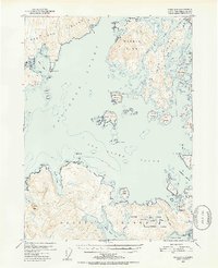 1951 Craig D-51953 Print · USGSCoastal Prince of Wales Island and its neighbors appear here in the early fifties, documenting a world of remote maritime camps and inlets. Researchers can find former industrial sites like Tokeen and the Lumber Camp (Abandoned) near Tonowek Bay.5 unique versions available
 - 1957 Map of Craig, 1959 Print
 1957 Craig1959 Print · USGSSoutheast Alaska’s intricate archipelago is revealed in the mid-1950s, detailing a coastal economy driven by remote mines and fishing outposts. Genealogists and historians can trace family roots in Craig, Hydaburg, and Klawak, or locate former sites like Tuxekan and the Salt Chuck Mine.3 unique versions available
 - 1996 Map of Craig D-5, 2000 Print
 1996 Craig D-52000 Print · USGSThe maritime timber economy of the Prince of Wales-Hyder region is captured in the late nineties, documenting the remote outposts of the Alaskan archipelago. Genealogists and historians can locate industrial hubs like the Logging Camp and the historic Tokeen (Site).
 - 2017 Map of Craig D-5 NE, 2017 Print
 2017 Craig D-5 NE2017 Print · USGSCovers Old Tokeen, including Unorganized Borough, Prince of Wales-Hyder, and other nearby areas
 - 2021 Map of Craig D-5 NE, 2021 Print
 2021 Craig D-5 NE2021 Print · USGSSoutheast Alaska's intricate island geography is charted here in the early twenty-first century. Researchers can trace maritime routes through El Capitan Passage and locate specific coastal landmarks like Tokeen and White Point.
End of results
Showing maps 1-5 of 5
Frequently asked questions
- What are the different types of historical maps available for Old Tokeen?
- What is the oldest map of Old Tokeen?
- Where can I purchase historical maps of Old Tokeen for my home or office?
- Where can I download high-res historical maps of Old Tokeen?
- Are there historical topographic maps available for Old Tokeen?
- Is there historical aerial imagery available for Old Tokeen?
- Where are historical maps of Old Tokeen sourced from?