Old Maps of Port Alice, Alaska for Hiking & Exploration
Hike through history with 5 historic maps of Port Alice. Explore old trails, ghost towns, and forgotten backroads — perfect for outdoor adventurers and local explorers.
- Rediscover forgotten places: Map out old mining camps, roads, and footpaths that no longer exist on modern maps.
- Layer with modern tools: Combine with LiDAR or satellite views to plan hikes through historical terrain.
- Made for exploration: Popular among hikers, overlanders, and local history lovers.
Use these maps to find adventure and explore the hidden past of Port Alice.
Port Alice, AK maps
(5)- 1951 Map of Craig D-5, 1953 Print
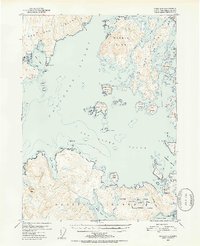 1951 Craig D-51953 Print · USGSCoastal Prince of Wales Island and its neighbors appear here in the early fifties, documenting a world of remote maritime camps and inlets. Researchers can find former industrial sites like Tokeen and the Lumber Camp (Abandoned) near Tonowek Bay.5 unique versions available
 - 1957 Map of Craig, 1959 Print
 1957 Craig1959 Print · USGSSoutheast Alaska’s intricate archipelago is revealed in the mid-1950s, detailing a coastal economy driven by remote mines and fishing outposts. Genealogists and historians can trace family roots in Craig, Hydaburg, and Klawak, or locate former sites like Tuxekan and the Salt Chuck Mine.3 unique versions available
 - 1996 Map of Craig D-5, 2000 Print
 1996 Craig D-52000 Print · USGSThe maritime timber economy of the Prince of Wales-Hyder region is captured in the late nineties, documenting the remote outposts of the Alaskan archipelago. Genealogists and historians can locate industrial hubs like the Logging Camp and the historic Tokeen (Site).
 - 2017 Map of Craig D-5 SW, 2017 Print
 2017 Craig D-5 SW2017 Print · USGSCovers Port Alice, including Unorganized Borough, Prince of Wales-Hyder, and other nearby areas
 - 2021 Map of Craig D-5 SW, 2021 Print
 2021 Craig D-5 SW2021 Print · USGSHeceta Island and the surrounding Alexander Archipelago are shown in the modern era as a hub of coastal forestry. Researchers can trace the network of timber access trails like Inverted Tree and No Where near the settlement of Port Alice.
End of results
Showing maps 1-5 of 5
Frequently asked questions
- What are the different types of historical maps available for Port Alice?
- What is the oldest map of Port Alice?
- Where can I purchase historical maps of Port Alice for my home or office?
- Where can I download high-res historical maps of Port Alice?
- Are there historical topographic maps available for Port Alice?
- Is there historical aerial imagery available for Port Alice?
- Where are historical maps of Port Alice sourced from?