Old Maps of Baranof Warm Springs, Alaska for Genealogy
Trace your family roots with 8 historic maps of Baranof Warm Springs. These high-res maps reveal old neighborhoods, homesites, landmarks, and streets — helping you uncover where your ancestors lived and how the area evolved over time.
- Explore historic neighborhoods: Identify where your relatives may have lived in the 1800s or 1900s.
- Compare maps over time: Trace the changes in streets, buildings, and landmarks for multi-generational research.
- Perfect for genealogy & ancestry research: Used by family historians and researchers to map out lineage and migration.
These maps are an incredible resource for exploring your personal connection to Baranof Warm Springs's past.
Baranof Warm Springs, AK maps
(8)- 1948 Map of Sitka A-3, 1956 Print
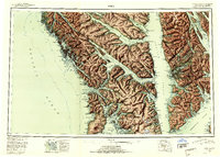
 1948 Sitka A-31956 Print · USGSThe eastern shore of Baranof Island comes into focus in the late 1940s, highlighting remote settlements and maritime landmarks. Researchers can locate the settlement of Manleyville, the Sawmill (Aband) at Kasnyku Bay, and natural features like the Hot Spring near Baranof Lake.
 - 1951 Map of Sitka, 1958 Print
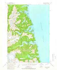
 1951 Sitka1958 Print · USGSSoutheast Alaska in the early fifties reveals a landscape defined by water and remote coastal outposts. Genealogists and historians can trace established settlements like Sitka and Angoon alongside industrial markers like a Logging Camp and the Old Sitka ruins.6 unique versions available
 - 1951 Map of Sitka A-3, 1966 Print
 1951 Sitka A-31966 Print · USGSBaranof Island is mapped here in the mid-1950s, showing the remote settlements and rugged maritime outposts along Chatham Strait. Researchers can trace the waterfront infrastructure at Baranof, find the Seaplane Base, and locate landmarks like Manleyville and Bahovec Peak.2 unique versions available
 - 1952 Map of Sitka, 1953 Print
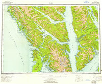
 1952 Sitka1953 Print · USGSSoutheast Alaska in the early fifties is mapped here across the islands and straits of the Alexander Archipelago. Researchers can locate coastal outposts like Angoon and Tenakee, or trace the rugged shores of Sitka Sound to the slopes of Mt Edgecumbe.4 unique versions available
 - 1964 Map of Sitka
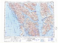 1964 Sitka1964 Print · USGSSoutheast Alaska's rugged archipelago is captured in the mid-twentieth century as maritime commerce and coastal outposts shaped the region. Genealogists and historians can trace established settlements like Sitka and Angoon or vanished points such as Gypsum and Manleyville.
 - 1996 Map of Sitka A-3, 2000 Print
 1996 Sitka A-32000 Print · USGSBaranof Island and the Chatham Strait coastline are captured here in the mid-1990s, showing a landscape of alpine peaks and isolated coastal stations. Researchers can locate the Fish Hatchery (State) near Hidden Falls and trace the remote settlement at Manleyville.
 - 2017 Map of Sitka A-3 SW, 2017 Print
 2017 Sitka A-3 SW2017 Print · USGSCovers Baranof Warm Springs, including Sitka, United States, and other nearby areas
 - 2021 Map of Sitka A-3 SW, 2021 Print
 2021 Sitka A-3 SW2021 Print · USGSThe Baranof Island wilderness comes into focus in this contemporary survey of the Sitka region. Researchers can trace the waterfront settlement of Baranof and remote features like Warm Spring, Baranof Lake, and the heights of Mt Furuhelm.
End of results
Showing maps 1-8 of 8
Frequently asked questions
- What are the different types of historical maps available for Baranof Warm Springs?
- What is the oldest map of Baranof Warm Springs?
- Where can I purchase historical maps of Baranof Warm Springs for my home or office?
- Where can I download high-res historical maps of Baranof Warm Springs?
- Are there historical topographic maps available for Baranof Warm Springs?
- Is there historical aerial imagery available for Baranof Warm Springs?
- Where are historical maps of Baranof Warm Springs sourced from?