Old Maps of Todd, Alaska for Academic Research
Study the evolution of Todd with 6 high-resolution historic maps. Whether you're teaching, researching, or modeling changes in land use, these maps provide essential visual documentation of urban, environmental, and geographic change.
- Analyze long-term change: Track patterns in development, transportation, and natural features.
- Ideal for environmental or urban studies: Support academic projects with primary historical map data.
- Use in the classroom or lab: Educators and researchers rely on these maps to bring historical context to life.
These maps are a powerful tool for teaching, research, and visualizing how Todd has changed over the decades.
Todd, AK maps
(6)- 1951 Map of Sitka B-4, 1956 Print
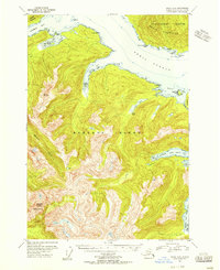 1951 Sitka B-41956 Print · USGSThe maritime wilderness of Baranof Island and Peril Strait is captured here in the mid-1950s, highlighting the remote coastal outposts of the First Judicial Division. Researchers can locate early navigation markers like McClellan Rk Light and isolated structures such as the Shelter Cabin near Lake Eva.3 unique versions available
 - 1951 Map of Sitka, 1958 Print
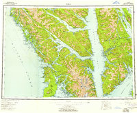 1951 Sitka1958 Print · USGSSoutheast Alaska in the early fifties reveals a landscape defined by water and remote coastal outposts. Genealogists and historians can trace established settlements like Sitka and Angoon alongside industrial markers like a Logging Camp and the Old Sitka ruins.6 unique versions available
 - 1952 Map of Sitka, 1953 Print
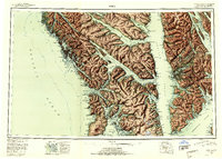 1952 Sitka1953 Print · USGSSoutheast Alaska in the early fifties is mapped here across the islands and straits of the Alexander Archipelago. Researchers can locate coastal outposts like Angoon and Tenakee, or trace the rugged shores of Sitka Sound to the slopes of Mt Edgecumbe.4 unique versions available
 - 1964 Map of Sitka
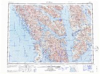 1964 Sitka1964 Print · USGSSoutheast Alaska's rugged archipelago is captured in the mid-twentieth century as maritime commerce and coastal outposts shaped the region. Genealogists and historians can trace established settlements like Sitka and Angoon or vanished points such as Gypsum and Manleyville.
 - 2017 Map of Sitka B-4 NE, 2017 Print
 2017 Sitka B-4 NE2017 Print · USGSCovers Todd, including Sitka, United States, and other nearby areas
 - 2021 Map of Sitka B-4 NE, 2021 Print
 2021 Sitka B-4 NE2021 Print · USGSChichagof Island and the waters of Peril Strait are captured in the early twenty-first century, revealing a landscape of coastal settlements and steep mountains. Researchers can trace land access via the Sitkoh Lake Spur Road Trl or locate the site of Todd and Lindenberg Harbor.
End of results
Showing maps 1-6 of 6
Frequently asked questions
- What are the different types of historical maps available for Todd?
- What is the oldest map of Todd?
- Where can I purchase historical maps of Todd for my home or office?
- Where can I download high-res historical maps of Todd?
- Are there historical topographic maps available for Todd?
- Is there historical aerial imagery available for Todd?
- Where are historical maps of Todd sourced from?