Old Maps of Lower Amulet, Adak for Hiking & Exploration
Hike through history with 6 historic maps of Lower Amulet. Explore old trails, ghost towns, and forgotten backroads — perfect for outdoor adventurers and local explorers.
- Rediscover forgotten places: Map out old mining camps, roads, and footpaths that no longer exist on modern maps.
- Layer with modern tools: Combine with LiDAR or satellite views to plan hikes through historical terrain.
- Made for exploration: Popular among hikers, overlanders, and local history lovers.
Use these maps to find adventure and explore the hidden past of Lower Amulet.
Lower Amulet, Adak maps
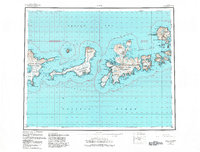
(6)- 1951 Map of Adak, 1953 Print
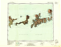 1951 Adak1953 Print · USGSThe Andreanof Islands appear in the mid-twentieth century as a vital maritime and strategic outpost between the Pacific and the Bering Sea. Researchers can trace the volcanic terrain of Kanaga Vol and locate early coastal features like the Cabin on Tanaga or the sheltered waters of Sweeper Cove.3 unique versions available
 - 1954 Map of Adak
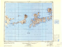 1954 Adak1954 Print · USGSAdak and the central Aleutian Islands appear here in the mid-fifties, during a peak period of Alaskan military and maritime activity. Researchers can trace the layout of Davis Air Force Base or locate remote outposts like the Cabins on Tanaga Island and Kanaga Island.
 - 1957 Map of Adak, 1968 Print
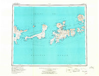 1957 Adak1968 Print · USGSAdak and its naval station are captured here in the late fifties, showing the area as a critical northern Pacific outpost. Researchers can trace military footprints around Sweeper Cove and find landmarks like Cemetery Pt and Kanaga Volcano.2 unique versions available
 - 1967 Map of Adak
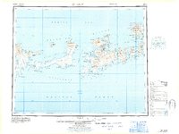 1967 Adak1967 Print · USGSAdak Island and the central Aleutians are documented here in the mid-1960s, a period of significant strategic importance for the remote military outpost. Researchers can trace the layout of the Adak Naval Air Station and locate surrounding landmarks like Mount Moffett and Clam Lagoon.
 - 1983 Map of Adak, 1984 Print
 1983 Adak1984 Print · USGSAdak Island during the early 1980s reveals the high-latitude infrastructure of a major Cold War naval installation. Researchers can trace the layout of the Adak Naval Station and Military Airport, alongside natural features like Mount Moffett and Finger Bay.
 - 2021 Map of Adak C-2 SW, 2021 Print
 2021 Adak C-2 SW2021 Print · USGSAdak Island in the early twenty-first century remains a landscape of military-era infrastructure meeting the wild Bering Sea coast. Local history enthusiasts can trace the road networks around Happy Valley and the shoreline near Hammerhead or navigate the inlets of Finger Bay and Scabbard Bay.
End of results
Showing maps 1-6 of 6
Frequently asked questions
- What are the different types of historical maps available for Lower Amulet?
- What is the oldest map of Lower Amulet?
- Where can I purchase historical maps of Lower Amulet for my home or office?
- Where can I download high-res historical maps of Lower Amulet?
- Are there historical topographic maps available for Lower Amulet?
- Is there historical aerial imagery available for Lower Amulet?
- Where are historical maps of Lower Amulet sourced from?