1900s (20th Century) Maps of Anvik, Alaska
Explore 3 historic maps of Anvik from the 1900s (20th Century). These maps offer a rare glimpse into what life looked like during the 1900s — showing old roads, neighborhoods, homes, and landmarks that have changed or disappeared over time.
Whether you're researching your family's past, planning a metal detecting trip, or studying how Anvik's landscape evolved across the 1900s, these high-resolution maps are a powerful tool for exploring the history of this region.
- Focus on a specific era: All maps on this page are from the 1900s, giving you a focused view of this time period.
- See what’s changed: Compare century-old streets, trails, and buildings to today's modern landscape using overlays and satellite layers.
- Research with precision: Use these maps for genealogy, historical research, land use analysis, or educational projects.
- View, download, or print: Maps are fully viewable online in high resolution, and can be downloaded or printed for your own records.
Start exploring Anvik's history through authentic maps from the 1900s. This is your window into the past.
Anvik, AK maps
(3)- 1951 Map of Holy Cross
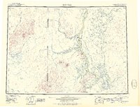 1951 Holy Cross1951 Print · USGSThe Yukon and Innoko river systems are captured here in the early fifties, showing the vital connection between river villages and seasonal routes. Researchers can trace the layout of Anvik, Holy Cross, and Shageluk, or locate remote points like Railroad City and Holikachuk.
 - 1952 Map of Holy Cross C-3, 1959 Print
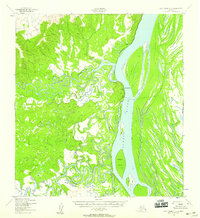 1952 Holy Cross C-31959 Print · USGSThe Yukon and Anvik rivers converge in the early fifties, showing a landscape defined by seasonal travel and remote settlements. Researchers can trace the Winter Trail across Elkhorn Island or locate riverside Cabins near Anvik and Hawk Bluff.2 unique versions available
 - 1952 Map of Holy Cross, 1960 Print
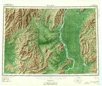 1952 Holy Cross1960 Print · USGSIn the Alaskan interior during the early fifties, life revolved around the great river systems and seasonal overland paths. Genealogists and researchers can trace the historic settlements at Anvik and Shageluk or follow the Reindeer Trail through the Holy Cross Hills.7 unique versions available
End of results
Showing maps 1-3 of 3
Top cities near Anvik
Frequently asked questions
- What are the different types of historical maps available for Anvik?
- What is the oldest map of Anvik?
- Where can I purchase historical maps of Anvik for my home or office?
- Where can I download high-res historical maps of Anvik?
- Are there historical topographic maps available for Anvik?
- Is there historical aerial imagery available for Anvik?
- Where are historical maps of Anvik sourced from?