Old Maps of Arolokovik, Alaska for Metal Detecting
Plan your next treasure hunt with 3 historic maps of Arolokovik. Find old homesites, ghost towns, trails, and gathering spots that may be lost to time — perfect for identifying promising metal detecting locations.
- Locate forgotten sites: Uncover places like long-lost settlements, abandoned rail lines, or gathering spots.
- Plan better hunts: Use map overlays combined with LiDAR or satellite views to narrow in on historically rich areas.
- Made for detectorists: Thousands of hobbyists use these maps to discover relics, coins, and hidden history.
Use these historic maps to boost your research and find new opportunities beneath the surface of Arolokovik.
Arolokovik, AK maps
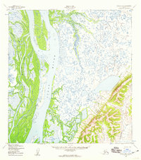
(3)- 1952 Map of Kwiguk
 1952 Kwiguk1952 Print · USGSThe Yukon Delta in the early fifties was a vast network of seasonal waterways and remote outposts. Researchers can trace the Winter Trail past Bill Moores or locate historic river settlements like New Fort Hamilton and Akulurak P O.8 unique versions available
 - 1952 Map of Kwiguk B-4, 1959 Print
 1952 Kwiguk B-41959 Print · USGSThe Yukon Delta's intricate waterways and seasonal routes are recorded here in the early fifties. Genealogists and historians can trace the specific location of Patsys Cabin or follow the path of the Winter Trail (Approximate) through the marshes.3 unique versions available
 - 2020 Map of Kwiguk B-4 NW, 2020 Print
 2020 Kwiguk B-4 NW2020 Print · USGSThe Yukon Delta's complex network of waterways is captured here in the early twenty-first century as it flows through the Kusilvak Census Area. Researchers can trace the massive braids of the Yukon River and the winding paths of Kwikpak Pass and Pektotolik Slough.
End of results
Showing maps 1-3 of 3
Frequently asked questions
- What are the different types of historical maps available for Arolokovik?
- What is the oldest map of Arolokovik?
- Where can I purchase historical maps of Arolokovik for my home or office?
- Where can I download high-res historical maps of Arolokovik?
- Are there historical topographic maps available for Arolokovik?
- Is there historical aerial imagery available for Arolokovik?
- Where are historical maps of Arolokovik sourced from?