Old Maps of Baker, Alaska for Academic Research
Study the evolution of Baker with 7 high-resolution historic maps. Whether you're teaching, researching, or modeling changes in land use, these maps provide essential visual documentation of urban, environmental, and geographic change.
- Analyze long-term change: Track patterns in development, transportation, and natural features.
- Ideal for environmental or urban studies: Support academic projects with primary historical map data.
- Use in the classroom or lab: Educators and researchers rely on these maps to bring historical context to life.
These maps are a powerful tool for teaching, research, and visualizing how Baker has changed over the decades.
Baker, AK maps
(7)- 1948 Map of Kantishna River, 1956 Print
 1948 Kantishna River1956 Print · USGSInterior Alaska during the late 1940s remained a frontier of river landings and winter trails before the era of major highway expansion. Genealogists and historians can trace the remote outposts of Manley Hot Springs Po, Roosevelt, and Toklat along the vast Kantishna River system.
 - 1951 Map of Kantishna River
 1951 Kantishna River1951 Print · USGSMid-century Alaska interior life is centered on river navigation and remote outposts like Manley Hot Springs and Roosevelt in the early 1950s. Researchers can trace historic transportation routes including a Sled Road and the Hot Springs Landing along the Tanana River.
 - 1952 Map of Kantishna River, 1957 Print
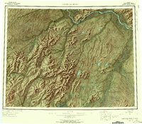 1952 Kantishna River1957 Print · USGSAlaska's interior wilderness in the early fifties was a landscape of remote river outposts and seasonal transit routes. Researchers can trace the decline of early settlements like Toklat and Nineteenmile or locate the historic Sled Road and Manley Hot Springs.7 unique versions available
 - 1953 Map of Kantishna River D-1, 1966 Print
 1953 Kantishna River D-11966 Print · USGSThe interior Alaska wilderness near the Tanana River is captured here in the mid-1950s, showing a landscape defined by braided waterways and vast wetlands. Researchers can trace the route of an old Sled Road and locate remote landmarks like Jennie M Island and Giroux Bluff.3 unique versions available
 - 1954 Map of Kantishna River D-1, 1956 Print
 1954 Kantishna River D-11956 Print · USGSThe Tanana River valley in the early 1950s reveals a world of braided waterways and seasonal winter trails. Genealogists and historians can locate a remote Cabin and trace the path of the Sled Road near Giroux Bluff.
 - 1964 Map of Kantishna River
 1964 Kantishna River1964 Print · USGSThe Alaska interior at the height of the Cold War reveals a river-dependent landscape where winter transport was still vital. Researchers can trace the Sled Road network and find former settlements like Toklat and Nineteenmile.
 - 2017 Map of Kantishna River D-1 NW, 2017 Print
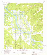
 2017 Kantishna River D-1 NW2017 Print · USGSThe interior Alaska wilderness along the Tanana River is captured here in the early twenty-first century. Researchers can trace the river's path past Giroux Bluff and locate island landmarks like Jennie M Island and Junction Island.
End of results
Showing maps 1-7 of 7
Frequently asked questions
- What are the different types of historical maps available for Baker?
- What is the oldest map of Baker?
- Where can I purchase historical maps of Baker for my home or office?
- Where can I download high-res historical maps of Baker?
- Are there historical topographic maps available for Baker?
- Is there historical aerial imagery available for Baker?
- Where are historical maps of Baker sourced from?