Old Maps of Blackburn, Alaska for Genealogy
Trace your family roots with 5 historic maps of Blackburn. These high-res maps reveal old neighborhoods, homesites, landmarks, and streets — helping you uncover where your ancestors lived and how the area evolved over time.
- Explore historic neighborhoods: Identify where your relatives may have lived in the 1800s or 1900s.
- Compare maps over time: Trace the changes in streets, buildings, and landmarks for multi-generational research.
- Perfect for genealogy & ancestry research: Used by family historians and researchers to map out lineage and migration.
These maps are an incredible resource for exploring your personal connection to Blackburn's past.
Blackburn, AK maps
(5)- 1951 Map of Unalakleet
 1951 Unalakleet1951 Print · USGSWestern Alaska's coastal and river corridors are captured in the early 1950s, showing the vital connection between Norton Sound and the interior. Researchers can trace the Winter Trail networks and locate remote outposts like Golsovia and the Coal Mine near Unalakleet.
 - 1952 Map of Unalakleet B-2, 1959 Print
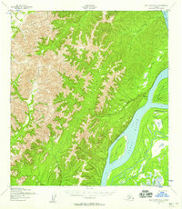 1952 Unalakleet B-21959 Print · USGSThe Yukon River interior during the early fifties reveals a landscape defined by seasonal movement and the remains of riverfront outposts. Researchers can trace the Winter Trail through the valley or locate the site of Blackburn (Aban'd) near Blackburn Island.2 unique versions available
 - 1952 Map of Unalakleet, 1960 Print
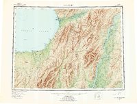 1952 Unalakleet1960 Print · USGSWestern Alaska in the early fifties shows a landscape of coastal settlements and interior river networks. Researchers can trace the Winter Trail and locate sites like the Williams Mine or the village of Unalakleet at the edge of the sound.8 unique versions available
 - 1964 Map of Unalakleet
 1964 Unalakleet1964 Print · USGSThe northern shores of Norton Sound and the interior Yukon River valley are documented here in the early sixties. Genealogists and researchers can trace remote outposts like Unalakleet, Golsovia, and the Williams Mine.
 - 2015 Map of Unalakleet B-2 NE, 2015 Print
 2015 Unalakleet B-2 NE2015 Print · USGSThe Yukon-Koyukuk interior remains a landscape of shifting river channels and seasonal drainages in this 2015 survey. Researchers can trace the massive Yukon River as it flows past Blackburn Island or follow the remote courses of Dugan Cr and Woods Cr.
End of results
Showing maps 1-5 of 5
Frequently asked questions
- What are the different types of historical maps available for Blackburn?
- What is the oldest map of Blackburn?
- Where can I purchase historical maps of Blackburn for my home or office?
- Where can I download high-res historical maps of Blackburn?
- Are there historical topographic maps available for Blackburn?
- Is there historical aerial imagery available for Blackburn?
- Where are historical maps of Blackburn sourced from?