Old Maps of Chandalar, Alaska for Metal Detecting
Plan your next treasure hunt with 5 historic maps of Chandalar. Find old homesites, ghost towns, trails, and gathering spots that may be lost to time — perfect for identifying promising metal detecting locations.
- Locate forgotten sites: Uncover places like long-lost settlements, abandoned rail lines, or gathering spots.
- Plan better hunts: Use map overlays combined with LiDAR or satellite views to narrow in on historically rich areas.
- Made for detectorists: Thousands of hobbyists use these maps to discover relics, coins, and hidden history.
Use these historic maps to boost your research and find new opportunities beneath the surface of Chandalar.
Chandalar, AK maps
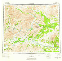
(5)- 1951 Map of Chandalar, 1952 Print
 1951 Chandalar1952 Print · USGSThe Brooks Range interior comes into focus in the early fifties, documenting a landscape of mining camps and river headwaters. Trace the legacy of gold prospectors through labels for the Beaver-Caro Wagon Road, the settlement of Caro, and the Gold Landing Strip.
 - 1956 Map of Chandalar, 1958 Print
 1956 Chandalar1958 Print · USGSThe Brooks Range wilderness of the mid-fifties is documented here through its complex river systems and isolated outposts. Researchers can locate the Venetie Indian Reservation and trace the Winter Trail past remote sites like Caro and Sixty-one Mile Cabin.8 unique versions available
 - 1964 Map of Chandalar
 1964 Chandalar1964 Print · USGSThe Alaskan interior during the mid-sixties reveals a landscape of isolated mining outposts and river-valley settlements connected by seasonal paths. Researchers can trace the Winter Trail through the hills or locate remote sites like Chandalar Mine, Venetie, and Sixty-one Mile Cabin.
 - 1990 Map of Chandalar C-3
 1990 Chandalar C-31990 Print · USGSUpper Yukon territory in the early 1990s reveals a landscape defined by mining prospects and seasonal transit. Trace the routes of the Winter Trail through the Brooks Range and locate remote industrial sites like Chandalar Mine and the Landing Strip.
 - 2017 Map of Chandalar C-3 SW, 2017 Print
 2017 Chandalar C-3 SW2017 Print · USGSThe Yukon-Koyukuk region of Alaska is captured here in the late 2010s, centered on the remote settlement of Chandalar. Researchers can trace the hub of local activity around the Chandalar Lake Airport and follow the path of the North Fork Chandalar River.
End of results
Showing maps 1-5 of 5
Frequently asked questions
- What are the different types of historical maps available for Chandalar?
- What is the oldest map of Chandalar?
- Where can I purchase historical maps of Chandalar for my home or office?
- Where can I download high-res historical maps of Chandalar?
- Are there historical topographic maps available for Chandalar?
- Is there historical aerial imagery available for Chandalar?
- Where are historical maps of Chandalar sourced from?