Old Maps of Chicken, Alaska for Hiking & Exploration
Hike through history with 5 historic maps of Chicken. Explore old trails, ghost towns, and forgotten backroads — perfect for outdoor adventurers and local explorers.
- Rediscover forgotten places: Map out old mining camps, roads, and footpaths that no longer exist on modern maps.
- Layer with modern tools: Combine with LiDAR or satellite views to plan hikes through historical terrain.
- Made for exploration: Popular among hikers, overlanders, and local history lovers.
Use these maps to find adventure and explore the hidden past of Chicken.
Chicken, AK maps
(5)- 1899 Map of Fortymile, 1902 Print
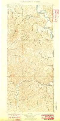 1899 Fortymile1902 Print · USGSThe Alaska-Yukon borderlands come into focus at the end of the nineteenth century during the height of the northern gold rushes. Local historians can trace early mining outposts and frontier hubs like Eagle City, Star City, and Seventymile along the Yukon River.3 unique versions available
 - 1951 Map of Eagle
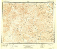 1951 Eagle1951 Print · USGSThe eastern Alaska wilderness at the Yukon border is captured here in the early fifties, a time when gold mining camps and bush outposts defined the interior. Trace the paths of prospectors through Chicken, Jack Wade, and the abandoned camp at Seventymile.4 unique versions available
 - 1956 Map of Eagle A-2, 1963 Print
 1956 Eagle A-21963 Print · USGSSoutheast Fairbanks during the mid-1950s reveals a landscape of isolated mining outposts and river-valley settlements. Trace the early routes of the Taylor Highway and locate remote landmarks like Chicken, Franklin, and the Lassen Landing Strip.2 unique versions available
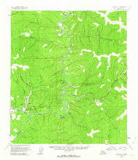
 - 1957 Map of Eagle, 1966 Print
 1957 Eagle1966 Print · USGSThe eastern Alaska interior comes into focus during the mid-fifties, showing the remote river outposts and mining camps along the Canadian border. Genealogists and historians can trace the early Taylor Highway corridor to Chicken, Jack Wade, and Eagle Village.6 unique versions available
 - 2018 Map of Eagle A-2 SW, 2018 Print
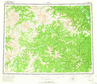
 2018 Eagle A-2 SW2018 Print · USGSThe community of Chicken is captured here in the late twenty-teens, situated at a critical junction of the historic Fortymile mining district. Researchers can trace the path of the Taylor Highway and locate landmarks like Lost Chicken Hill and the Chicken Airport.
End of results
Showing maps 1-5 of 5
Frequently asked questions
- What are the different types of historical maps available for Chicken?
- What is the oldest map of Chicken?
- Where can I purchase historical maps of Chicken for my home or office?
- Where can I download high-res historical maps of Chicken?
- Are there historical topographic maps available for Chicken?
- Is there historical aerial imagery available for Chicken?
- Where are historical maps of Chicken sourced from?