Old Maps of Council, Alaska for Genealogy
Trace your family roots with 4 historic maps of Council. These high-res maps reveal old neighborhoods, homesites, landmarks, and streets — helping you uncover where your ancestors lived and how the area evolved over time.
- Explore historic neighborhoods: Identify where your relatives may have lived in the 1800s or 1900s.
- Compare maps over time: Trace the changes in streets, buildings, and landmarks for multi-generational research.
- Perfect for genealogy & ancestry research: Used by family historians and researchers to map out lineage and migration.
These maps are an incredible resource for exploring your personal connection to Council's past.
Council, AK maps
(4)- 1950 Map of Solomon, 1956 Print
 1950 Solomon1956 Print · USGSThe southern Seward Peninsula is captured here in the mid-1950s, showing a landscape defined by coastal outposts and inland mining camps. Trace historic routes like the Winter Trail or locate the Big Hurrah Mine and Ruby Roadhouse.5 unique versions available
 - 1950 Map of Solomon D-4, 1956 Print
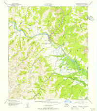 1950 Solomon D-41956 Print · USGSCouncil served as a remote hub for mining and aviation in the mid-twentieth century Seward Peninsula. Researchers can trace the path of the Abandoned RR and locate bush landing strips like Council Mine Landing Strip and Fox Bar Landing Strip.2 unique versions available
 - 1951 Map of Solomon
 1951 Solomon1951 Print · USGSThe Seward Peninsula during the mid-century shows the intricate network of mining trails and coastal outposts that followed the gold rushes. Researchers can trace the Seward Peninsula Railroad and locate interior settlements like Council or the Big Hurrah Mine.3 unique versions available
 - 2017 Map of Solomon D-4 NE, 2017 Print
 2017 Solomon D-4 NE2017 Print · USGSThe settlement of Council and the surrounding river valleys are captured here in the early twenty-first century. Researchers can trace local infrastructure and terrain features including the Council Airport, Ophir Gulch, and the winding Niukluk River.
End of results
Showing maps 1-4 of 4
Top cities near Council
Frequently asked questions
- What are the different types of historical maps available for Council?
- What is the oldest map of Council?
- Where can I purchase historical maps of Council for my home or office?
- Where can I download high-res historical maps of Council?
- Are there historical topographic maps available for Council?
- Is there historical aerial imagery available for Council?
- Where are historical maps of Council sourced from?