Old Maps of Elim, Alaska for Academic Research
Study the evolution of Elim with 7 high-resolution historic maps. Whether you're teaching, researching, or modeling changes in land use, these maps provide essential visual documentation of urban, environmental, and geographic change.
- Analyze long-term change: Track patterns in development, transportation, and natural features.
- Ideal for environmental or urban studies: Support academic projects with primary historical map data.
- Use in the classroom or lab: Educators and researchers rely on these maps to bring historical context to life.
These maps are a powerful tool for teaching, research, and visualizing how Elim has changed over the decades.
Elim, AK maps
(7)- 1950 Map of Solomon C-1, 1956 Print
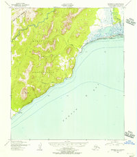 1950 Solomon C-11956 Print · USGSNorton Bay and the Seward Peninsula coast appear here in the early fifties as the region relied on seasonal routes and coastal outposts. Researchers can trace the Winter Trail connecting Elim and Walla Walla past the Moses Point Fishing Village.4 unique versions available
 - 1950 Map of Solomon, 1956 Print
 1950 Solomon1956 Print · USGSThe southern Seward Peninsula is captured here in the mid-1950s, showing a landscape defined by coastal outposts and inland mining camps. Trace historic routes like the Winter Trail or locate the Big Hurrah Mine and Ruby Roadhouse.5 unique versions available
 - 1951 Map of Solomon
 1951 Solomon1951 Print · USGSThe Seward Peninsula during the mid-century shows the intricate network of mining trails and coastal outposts that followed the gold rushes. Researchers can trace the Seward Peninsula Railroad and locate interior settlements like Council or the Big Hurrah Mine.3 unique versions available
 - 2014 Map of Solomon C-1 SE, 2014 Print
 2014 Solomon C-1 SE2014 Print · USGSIn the Nome Census Area during the early 21st century, this coastal survey captures the meeting point of the Seward Peninsula and the sea. Researchers can trace the exact shoreline of Norton Bay and the administrative grid of township T10S R18W.
 - 2014 Map of Solomon C-1 NE, 2014 Print
 2014 Solomon C-1 NE2014 Print · USGSCoastal life along Norton Bay in 2014 is centered on the seasonal activity of the Moses Point Fishing Village. Researchers can trace the local infrastructure from the Moses Point Airport to the banks of the Kwiniuk River.
 - 2014 Map of Solomon C-1 SW, 2014 Print
 2014 Solomon C-1 SW2014 Print · USGSThe southern coast of the Seward Peninsula comes into focus in this modern survey of the Seward Peninsula. Researchers can trace the area around Elim, locate the Elim Airport, and follow the remote Elim-Cape Darby Road toward Mount Kwinluk.
 - 2014 Map of Solomon C-1 NW, 2014 Print
 2014 Solomon C-1 NW2014 Print · USGSThe Seward Peninsula backcountry comes into focus in this modern survey of the Seward Peninsula. Researchers can trace the steep drainage basins of the Darby Mountains and the winding course of the Kwiniuk River and Iron Cr.
End of results
Showing maps 1-7 of 7
Frequently asked questions
- What are the different types of historical maps available for Elim?
- What is the oldest map of Elim?
- Where can I purchase historical maps of Elim for my home or office?
- Where can I download high-res historical maps of Elim?
- Are there historical topographic maps available for Elim?
- Is there historical aerial imagery available for Elim?
- Where are historical maps of Elim sourced from?