Old Maps of Farewell Lake, Alaska for Genealogy
Trace your family roots with 5 historic maps of Farewell Lake. These high-res maps reveal old neighborhoods, homesites, landmarks, and streets — helping you uncover where your ancestors lived and how the area evolved over time.
- Explore historic neighborhoods: Identify where your relatives may have lived in the 1800s or 1900s.
- Compare maps over time: Trace the changes in streets, buildings, and landmarks for multi-generational research.
- Perfect for genealogy & ancestry research: Used by family historians and researchers to map out lineage and migration.
These maps are an incredible resource for exploring your personal connection to Farewell Lake's past.
Farewell Lake, AK maps
(5)- 1949 Map of McGrath, 1955 Print
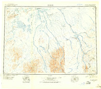 1949 McGrath1955 Print · USGSThe Alaskan interior at mid-century comes to life through this survey of the river valleys and mountain passes near McGrath. Trace old-world wilderness routes via the Winter Trail and remote stops like the Big River Roadhouse or the Rohn Roadhouse.
 - 1950 Map of McGrath
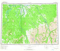
 1950 McGrath1950 Print · USGSThe Kuskokwim River valley and the Alaska Range foothills appear here at the dawn of the fifties. Trace the old interior supply routes through McGrath and Nikolai, or locate remote landmarks like Farewell Mtn Roadhouse and Rainy Pass.
 - 1958 Map of McGrath C-2, 1964 Print
 1958 McGrath C-21964 Print · USGSThe Alaskan interior near the South Fork Kuskokwim River is shown in the late 1950s as a remote transport and aviation hub. Researchers can trace the early layout of Farewell Airport, locate the Farewell Lake Lodge, and follow the seasonal Winter Trail.2 unique versions available
 - 1958 Map of McGrath, 1967 Print
 1958 McGrath1967 Print · USGSThe Alaskan interior at the end of the fifties reveals a landscape of river-braids and remote outposts centered on the confluence at McGrath. Researchers can trace the legacy of bush travel through sites like the Big River Roadhouse, Sterling Landing, and the high gateway at Rainy Pass.3 unique versions available
 - 2019 Map of McGrath C-2 SE, 2019 Print
 2019 McGrath C-2 SE2019 Print · USGSThe interior Alaskan wilderness comes into focus in this 2019 survey of the Yukon-Koyukuk area. Modern researchers can trace the braided path of the South Fork Kuskokwim River or locate remote landmarks like Farewell Mtn and Tin Creek Airport.
End of results
Showing maps 1-5 of 5
Frequently asked questions
- What are the different types of historical maps available for Farewell Lake?
- What is the oldest map of Farewell Lake?
- Where can I purchase historical maps of Farewell Lake for my home or office?
- Where can I download high-res historical maps of Farewell Lake?
- Are there historical topographic maps available for Farewell Lake?
- Is there historical aerial imagery available for Farewell Lake?
- Where are historical maps of Farewell Lake sourced from?