Old Maps of Fort Yukon, Alaska for Genealogy
Trace your family roots with 6 historic maps of Fort Yukon. These high-res maps reveal old neighborhoods, homesites, landmarks, and streets — helping you uncover where your ancestors lived and how the area evolved over time.
- Explore historic neighborhoods: Identify where your relatives may have lived in the 1800s or 1900s.
- Compare maps over time: Trace the changes in streets, buildings, and landmarks for multi-generational research.
- Perfect for genealogy & ancestry research: Used by family historians and researchers to map out lineage and migration.
These maps are an incredible resource for exploring your personal connection to Fort Yukon's past.
Fort Yukon, AK maps
(6)- 1951 Map of Fort Yukon
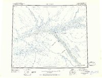 1951 Fort Yukon1951 Print · USGSThe Yukon Flats and the crossing of the Arctic Circle define this region during the early fifties. Researchers can trace seasonal wilderness routes like the Winter Trail and locate remote outposts from Venetie Landing to White Eye.
 - 1952 Map of Fort Yukon C-3, 1958 Print
 1952 Fort Yukon C-31958 Print · USGSFort Yukon sits at the strategic junction of two major rivers in the early 1950s, serving as a gateway to the Alaskan interior. Researchers can locate remote Cabins, trace the Winter Trail, and explore the geography of Homebrew Island and Williams Field.
 - 1955 Map of Fort Yukon C-3, 1963 Print
 1955 Fort Yukon C-31963 Print · USGSFort Yukon sits at the confluence of the Yukon and Porcupine Rivers in the mid-fifties, serving as a vital hub in the Alaskan interior. Genealogists and researchers can trace the early layout of the settlement near Williams Field and follow the route of the seasonal Winter Trail.3 unique versions available
 - 1956 Map of Fort Yukon, 1960 Print
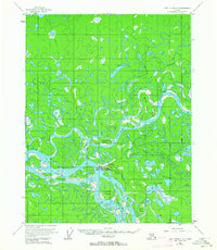
 1956 Fort Yukon1960 Print · USGSThe Yukon Flats and the Gwich'in homelands are captured here in the mid-fifties, centered on the historic river trading hub at Fort Yukon. Trace the seasonal routes of the interior via Winter Trail networks and locate isolated family landmarks like Bearman Cabin and Alexander Village.7 unique versions available
 - 2018 Map of Fort Yukon C-3 SE, 2018 Print
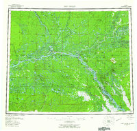
 2018 Fort Yukon C-3 SE2018 Print · USGSThe confluence of the Yukon and Porcupine Rivers is captured here in the early twenty-first century as the settlement of Fort Yukon expands. Genealogists and historians can trace the local street grid near Fort Yukon Airport or locate landmarks like Jenny Island and Sixmile Lake.
 - 2018 Map of Fort Yukon C-3 SW, 2018 Print
 2018 Fort Yukon C-3 SW2018 Print · USGSThe Yukon-Koyukuk region in 2018 centers on the vital junction of the Yukon River and the Porcupine River. Researchers can trace the local road network near the Fort Yukon Airport, including Husky Avenue and Burke Road, alongside several large river islands.
End of results
Showing maps 1-6 of 6
Frequently asked questions
- What are the different types of historical maps available for Fort Yukon?
- What is the oldest map of Fort Yukon?
- Where can I purchase historical maps of Fort Yukon for my home or office?
- Where can I download high-res historical maps of Fort Yukon?
- Are there historical topographic maps available for Fort Yukon?
- Is there historical aerial imagery available for Fort Yukon?
- Where are historical maps of Fort Yukon sourced from?