Old Maps of Ganes Creek, Alaska for Hiking & Exploration
Hike through history with 4 historic maps of Ganes Creek. Explore old trails, ghost towns, and forgotten backroads — perfect for outdoor adventurers and local explorers.
- Rediscover forgotten places: Map out old mining camps, roads, and footpaths that no longer exist on modern maps.
- Layer with modern tools: Combine with LiDAR or satellite views to plan hikes through historical terrain.
- Made for exploration: Popular among hikers, overlanders, and local history lovers.
Use these maps to find adventure and explore the hidden past of Ganes Creek.
Ganes Creek, AK maps
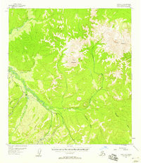
(4)- 1951 Map of Ophir
 1951 Ophir1951 Print · USGSThe Innoko River valley in the early fifties shows a landscape defined by gold mining and seasonal wilderness travel. Trace old routes like the Winter Trail and locate remote outposts such as Dishkakat (Aban'd) and Ophir.
 - 1954 Map of Ophir A-1, 1958 Print
 1954 Ophir A-11958 Print · USGSThe Innoko River valley in the mid-1950s reveals a landscape defined by isolated mining camps and the rugged terrain of the Alaska interior. Researchers can trace the legacy of resource extraction through labeled features like the Placer Mine, early Cabins, and the extensive Ditch systems near Yankee Creek.2 unique versions available
 - 1954 Map of Ophir, 1965 Print
 1954 Ophir1965 Print · USGSThe interior Alaska wilderness near the confluence of the Innoko and Dishna Rivers is documented here during the mid-fifties. Researchers can locate several legacy settlements including Dishkakat and Ophir, alongside a Placer Mine and the Winter Trail.3 unique versions available
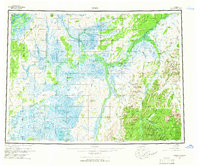
 - 2019 Map of Ophir A-1 SW, 2019 Print
 2019 Ophir A-1 SW2019 Print · USGSIn the Alaskan interior during the 2010s, this area centers on the settlement of Ganes Creek and its surrounding river valleys. Researchers can trace remote transit networks including the Sterling Landing-Takotna-Ophir Road and the Yankee Creek 2 Airport.
End of results
Showing maps 1-4 of 4
Frequently asked questions
- What are the different types of historical maps available for Ganes Creek?
- What is the oldest map of Ganes Creek?
- Where can I purchase historical maps of Ganes Creek for my home or office?
- Where can I download high-res historical maps of Ganes Creek?
- Are there historical topographic maps available for Ganes Creek?
- Is there historical aerial imagery available for Ganes Creek?
- Where are historical maps of Ganes Creek sourced from?