Old Maps of Goodnews Bay, Alaska
Explore 5 old maps of Goodnews Bay, spanning from 1951 to today. These high-resolution historic maps reveal how streets, neighborhoods, landmarks, and natural features evolved over time — perfect for genealogy, metal detecting, research, and local history exploration.
What you can do with these maps:
- See how Goodnews Bay changed over time: Compare historical maps to modern-day views to trace roads, homesites, rail lines & more.
- View detailed metadata: Each map includes creators, publishers, year, scale, and archive source.
- Overlay maps with satellite & LiDAR: Visualize the past alongside modern tools to explore terrain & human change.
- Trusted historical sources: Maps sourced from the USGS, Library of Congress, and other archives.
- Access maps your way: View online, download high-res files, or order prints for personal or research use.
Start exploring old maps of Goodnews Bay to uncover forgotten places, hidden landmarks, and the deep history beneath your feet.
Goodnews Bay, AK maps
(5)- 1951 Map of Goodnews, 1953 Print
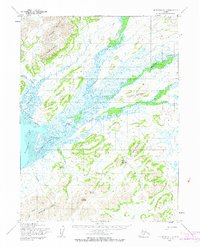
 1951 Goodnews1953 Print · USGSSouthwest Alaska’s coastal bays and mountain lakes are captured here just after the war, showing the area's shifting settlement patterns. Trace the coastline from Kwinhagak to Goodnews, or locate interior landmarks like the Placer Mine and Nuyakuk Lake.6 unique versions available
 - 1954 Map of Goodnews A-7, 1965 Print
 1954 Goodnews A-71965 Print · USGSThe coastal area around Goodnews Bay is shown in the mid-1950s, when river travel and wilderness trails connected isolated outposts. Researchers can locate the Landing Field at Goodnews, the Tunulik Lakes, and family-named peaks like Knight Mountain.3 unique versions available
 - 1979 Map of Goodnews Bay
 1979 Goodnews Bay1979 Print · USGSCoastal villages and massive mountain ranges define the southwestern Alaska wilderness during the late seventies. Researchers can trace remote routes like the Winter Trail and locate isolated outposts at Platinum and Goodnews Bay near Cape Newenham.2 unique versions available
 - 2017 Map of Goodnews Bay A-7 SW, 2017 Print
 2017 Goodnews Bay A-7 SW2017 Print · USGSThe coastal community of Goodnews Bay is shown in detail during the late twenty-teens, situated where the river meets the sea. Researchers can trace the local infrastructure near Goodnews Airport and locate prominent regional landmarks like Pyramid Mtn and Crater Hill.
 - 2017 Map of Goodnews Bay A-7 NW, 2017 Print
 2017 Goodnews Bay A-7 NW2017 Print · USGSThe coastal wilderness of Bethel, Alaska, is captured here in the early twenty-first century as river systems converge near the sea. Researchers can trace the winding paths of the Tunulik River and the Goodnews River as they flow past landmarks like Mumtrak Hill.
End of results
Showing maps 1-5 of 5
Top cities near Goodnews Bay
Frequently asked questions
- What are the different types of historical maps available for Goodnews Bay?
- What is the oldest map of Goodnews Bay?
- Where can I purchase historical maps of Goodnews Bay for my home or office?
- Where can I download high-res historical maps of Goodnews Bay?
- Are there historical topographic maps available for Goodnews Bay?
- Is there historical aerial imagery available for Goodnews Bay?
- Where are historical maps of Goodnews Bay sourced from?