Old Maps of Grayling, Alaska for Academic Research
Study the evolution of Grayling with 5 high-resolution historic maps. Whether you're teaching, researching, or modeling changes in land use, these maps provide essential visual documentation of urban, environmental, and geographic change.
- Analyze long-term change: Track patterns in development, transportation, and natural features.
- Ideal for environmental or urban studies: Support academic projects with primary historical map data.
- Use in the classroom or lab: Educators and researchers rely on these maps to bring historical context to life.
These maps are a powerful tool for teaching, research, and visualizing how Grayling has changed over the decades.
Grayling, AK maps
(5)- 1951 Map of Holy Cross
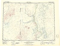 1951 Holy Cross1951 Print · USGSThe Yukon and Innoko river systems are captured here in the early fifties, showing the vital connection between river villages and seasonal routes. Researchers can trace the layout of Anvik, Holy Cross, and Shageluk, or locate remote points like Railroad City and Holikachuk.
 - 1952 Map of Holy Cross D-3, 1959 Print
 1952 Holy Cross D-31959 Print · USGSThe Yukon River interior comes into focus during the early 1950s, showing a landscape shaped by water and elevation. Trace early riverside outposts like Cabins and follow the route of a Trail near Eagle Island and the Yellow River.2 unique versions available
 - 1952 Map of Holy Cross, 1960 Print
 1952 Holy Cross1960 Print · USGSIn the Alaskan interior during the early fifties, life revolved around the great river systems and seasonal overland paths. Genealogists and researchers can trace the historic settlements at Anvik and Shageluk or follow the Reindeer Trail through the Holy Cross Hills.7 unique versions available
 - 2017 Map of Holy Cross D-3 NE, 2017 Print
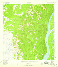
 2017 Holy Cross D-3 NE2017 Print · USGSGrayling occupies the west bank of the Yukon River in 2017, situated where the hills meet the river valley. Researchers can trace the layout of the townsite from Grayling Airport to local routes like Cemetery Lane and Hill Street.
 - 2017 Map of Holy Cross D-3 SE, 2017 Print
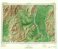
 2017 Holy Cross D-3 SE2017 Print · USGSThe Yukon-Koyukuk interior comes into focus during this 2017 survey, showcasing the wild west bank of the great river. Researchers can trace the steep topography and drainage of Blueberry Cr as it flows toward the main channel of the Yukon River.
End of results
Showing maps 1-5 of 5
Top cities near Grayling
Frequently asked questions
- What are the different types of historical maps available for Grayling?
- What is the oldest map of Grayling?
- Where can I purchase historical maps of Grayling for my home or office?
- Where can I download high-res historical maps of Grayling?
- Are there historical topographic maps available for Grayling?
- Is there historical aerial imagery available for Grayling?
- Where are historical maps of Grayling sourced from?