Old Maps of Holy Cross, Alaska for Metal Detecting
Plan your next treasure hunt with 5 historic maps of Holy Cross. Find old homesites, ghost towns, trails, and gathering spots that may be lost to time — perfect for identifying promising metal detecting locations.
- Locate forgotten sites: Uncover places like long-lost settlements, abandoned rail lines, or gathering spots.
- Plan better hunts: Use map overlays combined with LiDAR or satellite views to narrow in on historically rich areas.
- Made for detectorists: Thousands of hobbyists use these maps to discover relics, coins, and hidden history.
Use these historic maps to boost your research and find new opportunities beneath the surface of Holy Cross.
Holy Cross, AK maps
(5)- 1951 Map of Holy Cross
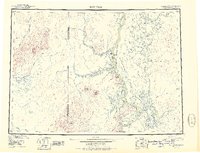 1951 Holy Cross1951 Print · USGSThe Yukon and Innoko river systems are captured here in the early fifties, showing the vital connection between river villages and seasonal routes. Researchers can trace the layout of Anvik, Holy Cross, and Shageluk, or locate remote points like Railroad City and Holikachuk.
 - 1952 Map of Holy Cross A-2, 1959 Print
 1952 Holy Cross A-21959 Print · USGSThe Yukon and Innoko rivers meet in the Alaska interior during the early 1950s, revealing a landscape of seasonal trails and river settlements. You can locate Holy Cross at the base of the hills and trace the Winter Trail as it passes Railroad City and numerous island cabins.3 unique versions available
 - 1952 Map of Holy Cross, 1960 Print
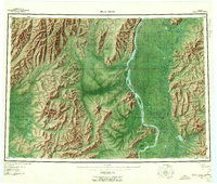 1952 Holy Cross1960 Print · USGSIn the Alaskan interior during the early fifties, life revolved around the great river systems and seasonal overland paths. Genealogists and researchers can trace the historic settlements at Anvik and Shageluk or follow the Reindeer Trail through the Holy Cross Hills.7 unique versions available
 - 2019 Map of Holy Cross A-2 NE, 2019 Print
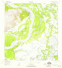
 2019 Holy Cross A-2 NE2019 Print · USGSThe Yukon-Koyukuk region in the late twenty-tens is defined by the convergence of major waterways and shifting river islands. Researchers can trace the complex braided channels of the Yukon River, Innoko River, and the distinct landform of Salmon Island.
 - 2019 Map of Holy Cross A-2 NW, 2019 Print
 2019 Holy Cross A-2 NW2019 Print · USGSThe community of Holy Cross is documented in this 2019 survey, illustrating the vital relationship between the settlement and the Yukon River. Researchers can trace local infrastructure like the Holy Cross Airport and rural routes such as Gost Creek Road.
End of results
Showing maps 1-5 of 5
Top neighborhoods of Holy Cross
Frequently asked questions
- What are the different types of historical maps available for Holy Cross?
- What is the oldest map of Holy Cross?
- Where can I purchase historical maps of Holy Cross for my home or office?
- Where can I download high-res historical maps of Holy Cross?
- Are there historical topographic maps available for Holy Cross?
- Is there historical aerial imagery available for Holy Cross?
- Where are historical maps of Holy Cross sourced from?