Old Maps of Jack Wade, Alaska
Explore 6 old maps of Jack Wade, spanning from 1899 to today. These high-resolution historic maps reveal how streets, neighborhoods, landmarks, and natural features evolved over time — perfect for genealogy, metal detecting, research, and local history exploration.
What you can do with these maps:
- See how Jack Wade changed over time: Compare historical maps to modern-day views to trace roads, homesites, rail lines & more.
- View detailed metadata: Each map includes creators, publishers, year, scale, and archive source.
- Overlay maps with satellite & LiDAR: Visualize the past alongside modern tools to explore terrain & human change.
- Trusted historical sources: Maps sourced from the USGS, Library of Congress, and other archives.
- Access maps your way: View online, download high-res files, or order prints for personal or research use.
Start exploring old maps of Jack Wade to uncover forgotten places, hidden landmarks, and the deep history beneath your feet.
Jack Wade, AK maps
(6)- 1899 Map of Fortymile, 1902 Print
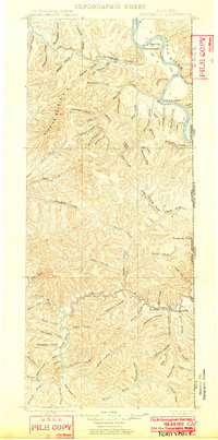 1899 Fortymile1902 Print · USGSThe Alaska-Yukon borderlands come into focus at the end of the nineteenth century during the height of the northern gold rushes. Local historians can trace early mining outposts and frontier hubs like Eagle City, Star City, and Seventymile along the Yukon River.3 unique versions available
 - 1951 Map of Eagle
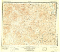 1951 Eagle1951 Print · USGSThe eastern Alaska wilderness at the Yukon border is captured here in the early fifties, a time when gold mining camps and bush outposts defined the interior. Trace the paths of prospectors through Chicken, Jack Wade, and the abandoned camp at Seventymile.4 unique versions available
 - 1956 Map of Eagle A-1, 1963 Print
 1956 Eagle A-11963 Print · USGSThe Fortymile mining district in the mid-1950s reveals a landscape of remote resource extraction along the Canada border. Trace the remnants of the gold rush era via Dredge Tailings, the settlement of Jack Wade, and high-altitude landmarks like Davis Dome.4 unique versions available
 - 1957 Map of Eagle, 1966 Print
 1957 Eagle1966 Print · USGSThe eastern Alaska interior comes into focus during the mid-fifties, showing the remote river outposts and mining camps along the Canadian border. Genealogists and historians can trace the early Taylor Highway corridor to Chicken, Jack Wade, and Eagle Village.6 unique versions available
 - 2018 Map of Eagle A-1 NW, 2018 Print
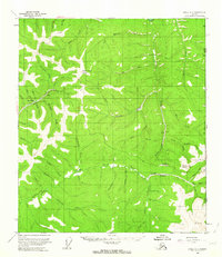
 2018 Eagle A-1 NW2018 Print · USGSCovers Jack Wade, including Unorganized Borough, United States, and other nearby areas
 - 2023 Map of Eagle A-1 NW, 2023 Print
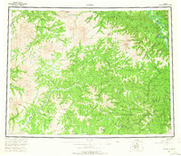
 2023 Eagle A-1 NW2023 Print · USGSThe interior Alaskan wilderness near the Yukon border is mapped here in the modern era. Researchers can trace the winding Taylor Highway past the settlement of Jack Wade and the protected Fortymile Wild and Scenic River.
End of results
Showing maps 1-6 of 6
Frequently asked questions
- What are the different types of historical maps available for Jack Wade?
- What is the oldest map of Jack Wade?
- Where can I purchase historical maps of Jack Wade for my home or office?
- Where can I download high-res historical maps of Jack Wade?
- Are there historical topographic maps available for Jack Wade?
- Is there historical aerial imagery available for Jack Wade?
- Where are historical maps of Jack Wade sourced from?