1900s (20th Century) Maps of Kashega, Alaska
Explore 2 historic maps of Kashega from the 1900s (20th Century). These maps offer a rare glimpse into what life looked like during the 1900s — showing old roads, neighborhoods, homes, and landmarks that have changed or disappeared over time.
Whether you're researching your family's past, planning a metal detecting trip, or studying how Kashega's landscape evolved across the 1900s, these high-resolution maps are a powerful tool for exploring the history of this region.
- Focus on a specific era: All maps on this page are from the 1900s, giving you a focused view of this time period.
- See what’s changed: Compare century-old streets, trails, and buildings to today's modern landscape using overlays and satellite layers.
- Research with precision: Use these maps for genealogy, historical research, land use analysis, or educational projects.
- View, download, or print: Maps are fully viewable online in high resolution, and can be downloaded or printed for your own records.
Start exploring Kashega's history through authentic maps from the 1900s. This is your window into the past.
Kashega, AK maps
(2)- 1951 Map of Unalaska, 1952 Print
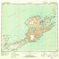 1951 Unalaska1952 Print · USGSThe Fox Islands are shown during the strategic post-war period when military installations still guarded the Aleutian chain. Genealogists and historians can trace the locations of Makushin and Kashega alongside the footprints of Fort Mears and Fort Glenn.10 unique versions available
 - 1989 Map of Unalaska A-4
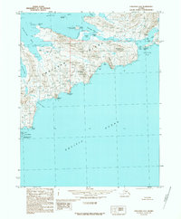 1989 Unalaska A-41989 Print · USGSUnalaska Island in the late eighties remains a landscape of untouched coastal features between the Bering Sea and the Pacific. Trace the remote shorelines of Kashega Bay, the high elevations of Risky Ridge, and the Aleutian Island Wilderness.
End of results
Showing maps 1-2 of 2
Frequently asked questions
- What are the different types of historical maps available for Kashega?
- What is the oldest map of Kashega?
- Where can I purchase historical maps of Kashega for my home or office?
- Where can I download high-res historical maps of Kashega?
- Are there historical topographic maps available for Kashega?
- Is there historical aerial imagery available for Kashega?
- Where are historical maps of Kashega sourced from?