1900s (20th Century) Maps of Kipnuk, Alaska
Explore 3 historic maps of Kipnuk from the 1900s (20th Century). These maps offer a rare glimpse into what life looked like during the 1900s — showing old roads, neighborhoods, homes, and landmarks that have changed or disappeared over time.
Whether you're researching your family's past, planning a metal detecting trip, or studying how Kipnuk's landscape evolved across the 1900s, these high-resolution maps are a powerful tool for exploring the history of this region.
- Focus on a specific era: All maps on this page are from the 1900s, giving you a focused view of this time period.
- See what’s changed: Compare century-old streets, trails, and buildings to today's modern landscape using overlays and satellite layers.
- Research with precision: Use these maps for genealogy, historical research, land use analysis, or educational projects.
- View, download, or print: Maps are fully viewable online in high resolution, and can be downloaded or printed for your own records.
Start exploring Kipnuk's history through authentic maps from the 1900s. This is your window into the past.
Kipnuk, AK maps
(3)- 1951 Map of Kuskokwim Bay
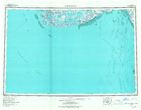
 1951 Kuskokwim Bay1951 Print · USGSThe coastal margins of the Bering Sea in the mid-century reveal a world of isolated settlements and river mouths. Researchers can trace the layout of Kwinhagak, Kipnuk, and Kongiganak along the reaches of Kuskokwim Bay and the Kanektok River.
 - 1954 Map of Kuskokwim Bay, 1967 Print
 1954 Kuskokwim Bay1967 Print · USGSCoastal life in western Alaska during the mid-fifties centered on river mouths and tundra lakes. Researchers can trace remote settlements like Kipnuk and Kongiganak or locate the Seaplane Anchorage used for essential regional transit.3 unique versions available
 - 1954 Map of Kuskokwim Bay D-6, 1971 Print
 1954 Kuskokwim Bay D-61971 Print · USGSCoastal Alaska in the late fifties and early seventies reveals a landscape of shifting tides and remote outposts. Trace the early layout of Kipnuk and Anogok, and locate the essential Seaplane Anchorage near the Kuguklik River.
End of results
Showing maps 1-3 of 3
Top cities near Kipnuk
Frequently asked questions
- What are the different types of historical maps available for Kipnuk?
- What is the oldest map of Kipnuk?
- Where can I purchase historical maps of Kipnuk for my home or office?
- Where can I download high-res historical maps of Kipnuk?
- Are there historical topographic maps available for Kipnuk?
- Is there historical aerial imagery available for Kipnuk?
- Where are historical maps of Kipnuk sourced from?