Old Maps of Klukwan, Alaska
Explore 5 old maps of Klukwan, spanning from 1952 to today. These high-resolution historic maps reveal how streets, neighborhoods, landmarks, and natural features evolved over time — perfect for genealogy, metal detecting, research, and local history exploration.
What you can do with these maps:
- See how Klukwan changed over time: Compare historical maps to modern-day views to trace roads, homesites, rail lines & more.
- View detailed metadata: Each map includes creators, publishers, year, scale, and archive source.
- Overlay maps with satellite & LiDAR: Visualize the past alongside modern tools to explore terrain & human change.
- Trusted historical sources: Maps sourced from the USGS, Library of Congress, and other archives.
- Access maps your way: View online, download high-res files, or order prints for personal or research use.
Start exploring old maps of Klukwan to uncover forgotten places, hidden landmarks, and the deep history beneath your feet.
Klukwan, AK maps
(5)- 1952 Map of Skagway, 1953 Print
 1952 Skagway1953 Print · USGSThe northern reaches of the Alaska Panhandle come alive in the early fifties, showing the vital rail and road links to the Yukon. Trace the historic White Pass & Yukon Route or locate remote camps like Pleasant Camp and Klukwan.4 unique versions available
 - 1954 Map of Skagway B-3, 1959 Print
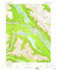 1954 Skagway B-31959 Print · USGSSoutheast Alaska in the mid-fifties reveals a landscape of glacial rivers and historic transit routes near the Canadian border. Genealogists and historians can trace the paths of the Indian Trail and Dalton Trail past the settlement of Klukwan and the cabins at Wells.2 unique versions available
 - 1961 Map of Skagway, 1967 Print
 1961 Skagway1967 Print · USGSThe northern reaches of the Panhandle and the rugged border with British Columbia come into focus in the early sixties. Researchers can trace the historic Chilkoot Trail, the White Pass and Yukon Railway, and coastal outposts like Klukwan.4 unique versions available
 - 1991 Map of Skagway B-3 NE
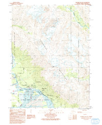 1991 Skagway B-3 NE1991 Print · USGSSoutheast Alaska in the early nineties reveals a landscape of massive glacial rivers and ancient settlements. Trace the junction of the Chilkat River and Klehini River to find the village of Klukwan, its local Cem, and the crossing at Wells Bridge.
 - 2017 Map of Skagway B-3 NE, 2017 Print
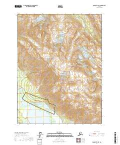 2017 Skagway B-3 NE2017 Print · USGSThe confluence of the Chilkat, Tsirku, and Klehini rivers defines this 2017 survey of the Haines Borough. Trace the paths of the Haines Highway and Klukwan Road as they link the settlements of Klukwan, Wells, and Chilkat.
End of results
Showing maps 1-5 of 5
Top cities near Klukwan
Frequently asked questions
- What are the different types of historical maps available for Klukwan?
- What is the oldest map of Klukwan?
- Where can I purchase historical maps of Klukwan for my home or office?
- Where can I download high-res historical maps of Klukwan?
- Are there historical topographic maps available for Klukwan?
- Is there historical aerial imagery available for Klukwan?
- Where are historical maps of Klukwan sourced from?