
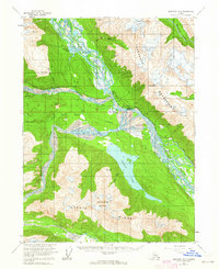
1954 Map of Skagway B-3
USGS Topo · Published 1959About this map
Klukwan and the confluence of the Chilkat River and Klehini River anchor this mid-century look at the Alaskan panhandle's glacial valleys. The map documents a landscape defined by historic transit corridors, showing the overlap of the Indian Trail and the Dalton Trail as they navigate the braided river systems. The industrial footprint of the era is marked by a Sawmill and the Haines Highway, alongside a Pipeline cutting through the terrain. To the south, Chilkat Lake sits beneath Chunekukleik Mountain, fed by Annuin Creek. The presence of scattered Cabins and the settlement at Wells reflects the sparse but strategic human presence in these mountain-locked basins. The detailed hydrography, including Mosquito Lake and the silty reaches of the Tsirku River, illustrates the shifting nature of this river-dominated geography.
Find a feature on this map
32 named features on this map. Tap any name to fly to it.
Don’t see what you’re looking for? This feature index may not catch every label — zoom into the map to look around manually.
Map Details
Editions of this 1954 Skagway B-3 Map
2 editions found
Other maps of this area

1948 · Skagway C-4
USGS Topo · 1:63,360

1948 · Skagway C-3
USGS Topo · 1:63,360

1948 · Skagway C-2
USGS Topo · 1:63,360

1951 · Skagway C-2
USGS Topo · 1:63,360

1952 · Skagway
USGS Topo · 1:250,000

1954 · Skagway B-2
USGS Topo · 1:63,360

1954 · Skagway A-3
USGS Topo · 1:63,360

1954 · Skagway A-2
USGS Topo · 1:63,360

1954 · Skagway B-4
USGS Topo · 1:63,360
1954 · Skagway C-4
USGS Topo · 1:63,360