Old Maps of Makushin, Alaska for Genealogy
Trace your family roots with 3 historic maps of Makushin. These high-res maps reveal old neighborhoods, homesites, landmarks, and streets — helping you uncover where your ancestors lived and how the area evolved over time.
- Explore historic neighborhoods: Identify where your relatives may have lived in the 1800s or 1900s.
- Compare maps over time: Trace the changes in streets, buildings, and landmarks for multi-generational research.
- Perfect for genealogy & ancestry research: Used by family historians and researchers to map out lineage and migration.
These maps are an incredible resource for exploring your personal connection to Makushin's past.
Makushin, AK maps
(3)- 1951 Map of Unalaska, 1952 Print
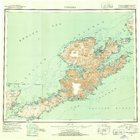 1951 Unalaska1952 Print · USGSThe Fox Islands are shown during the strategic post-war period when military installations still guarded the Aleutian chain. Genealogists and historians can trace the locations of Makushin and Kashega alongside the footprints of Fort Mears and Fort Glenn.10 unique versions available
 - 1989 Map of Unalaska C-3
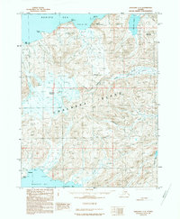 1989 Unalaska C-31989 Print · USGSUnalaska Island's volcanic interior is documented in the late 1980s, showcasing the high peaks and coastal bights of the Aleutian chain. Researchers can trace the remote Landing Strip at Driftwood Bay or locate landmarks like Makushin Volcano and McLees Lake.
 - 2021 Map of Unalaska C-3 SW, 2021 Print
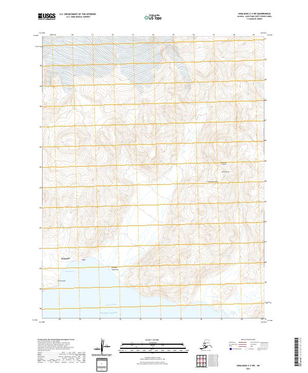 2021 Unalaska C-3 SW2021 Print · USGSUnalaska Island in the early twenty-first century remains a landscape of high coastal ridges and protected maritime inlets. Researchers can locate the settlement at Makushin and trace the rugged shoreline from Old Harbor to the landmark at Priest Rock.
End of results
Showing maps 1-3 of 3
Top cities near Makushin
Frequently asked questions
- What are the different types of historical maps available for Makushin?
- What is the oldest map of Makushin?
- Where can I purchase historical maps of Makushin for my home or office?
- Where can I download high-res historical maps of Makushin?
- Are there historical topographic maps available for Makushin?
- Is there historical aerial imagery available for Makushin?
- Where are historical maps of Makushin sourced from?